We're working the SCI convention in Reno again this year (1/26-1/30) and it looks like Cal is getting pounded again with rain, wind, and snow like last year.
I'm wondering if there is a better or easier route there from Mt Shasta. Last year we played it safe and drove all the way down to Sacramento and went over Donner pass(never missed a meal

). They closed it about an hour after we got down to Truckee.
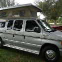
The van drove beautifully through all that snow. It was very responsive the couple times when we had to dodge an out of control subaru once and a prius looking car flying sideways into a snow bank. (The chain up guys at all the stops got a kick out of our van and just waived us on, driving snow and all). Even in the driving rain and 60+ mph winds on I5 north of Sacramento was no problem.
So is there an better way? If weather cooperates I'd love to just go down CA89 thru Susanville or even CA36 at Red Bluff? but it looks like those roads are closed for winter?
Not being from Cal it is hard to make sense of the Caltrans current conditions website since I dont know county lines or mile markers and it seems thats what they use in the descriptions. I check the webcams often but they dont seem to be in the bad areas.
We do have 3 days to get there from P town and if it has to be Sacramento to 80 again, so be it but just wondering if I'm missing another option. And yes I know conditions change hour to hour.
By the way Merry Christmas & Happy New Year to all.
Harry

__________________
09 E350 EB 6.0PSD SMB 4x4 kind of a 61 layout
02 F450 Flatbed 4x4 7.3 PSD
08 F150 5.4 ltr 4x4 Daily Driver
77 Orig Bronco in rebuild mode "uncut"
76 Orig Bronco rebuilt & driven weekly
71 Orig Bronco rebuilt & 4sale gots everything on it
Owned a jimmy once for about 6 months.
https://www.tropicalgardensofmaui.com
https://www.mauicabins.com
twitter @runnin6mpg


 Just follow the age old boy scout motto and "Be prepaired"!
 Linear Mode