|
|
 10-15-2009, 10:15 AM
|
#11
|
|
Senior Member
Join Date: Jan 2009
Posts: 1,220
|
Re: Colorado Plateau Parks Tour - Fall 2009
Ed,
Did you need a campground reservation at Arches?
__________________
Len & Joanne
The Green TARDIS
|

|

|
|
10-15-2009, 10:57 AM
|
#12
|
|
Senior Member
Join Date: Jun 2007
Location: Helena, Montana
Posts: 613
|
Re: Colorado Plateau Parks Tour - Fall 2009
Len, my wife and I didn't stay in Arches National Park but camped right across the river from the park at the BLM campsites. My wife's sister was planning to camp in Arches the night before we arrived (but couldn't) and had a reserved site with the NPS. Apparently in September and October, the park's campsites fill up by mid-morning, and reservations are necessary.
__________________
2006 Baja Tan SMB 4X4 EB50 PH 6LPSD
Mohawk Royalex Solo 14 foot canoe (light white-water)
Mad River Kevlar Explorer 17 foot canoe (flat water)
Dagger Royalex Legend 16 foot canoe (white-water)
Maravia New Wave 13.5 foot raft (fishing and white-water)
|
|
|
|
|
10-15-2009, 12:23 PM
|
#13
|
|
Senior Member
Join Date: Jan 2009
Posts: 1,220
|
Re: Colorado Plateau Parks Tour - Fall 2009
Ed,
Thanks for the fast reply!! The Arches area will be our first STOP after coming cross country from Michigan - 3 days of eating up miles -. We plan on spending 3 nights in that area. I ASSUME there was no problem finding a BLM site. Looks like there are many in the area.
Again your pics are great.
__________________
Len & Joanne
The Green TARDIS
|
|
|
|
|
10-16-2009, 06:42 AM
|
#14
|
|
Senior Member
Join Date: Jun 2007
Location: Helena, Montana
Posts: 613
|
Re: Colorado Plateau Parks Tour - Fall 2009
DAY FIVE WEDNESDAY AFTERNOON
PALISADE, CO TO MESA VERDE NATIONAL PARK, CO
Going downhill toward the town the Dolores River Canyon, we stop for lunch at a small rest stop a few miles east of the town of Gateway, Colorado. While walking the dogs next to a small stream I begin to have second thoughts about this. The vehicles are parked under old cottonwood trees that are being buffeted hard by the high winds from the cold front passing through. Old cottonwoods are renowned for shedding limbs and there are already a few small ones on the ground. We decide to find someplace thats less wooded for a stop in this windy weather.
Driving through the town of Gateway, Im stunned to see the new ritzy resort on the west side of town. It looks completely out of place in this remote canyon country, like a piece of Aspen plopped down in the desert. It even has an Adventure Center, where guests can sign up for canyon trips. I recall one definition of an adventure is a trip gone wrong.
Its hard to find any place in this lower Dolores River Canyon to pull over, but we finally find a wide place in the road and stop for lunch, without fear of falling tree limbs.

The lower Dolores River Canyon is spectacular red rock canyon country.

Getting back on the road, SR 141 climbs out of the Dolores Canyon and heads up the valley of the San Miguel River, which has a beautiful riparian zone of trees with great Fall colors.
Turning to the southwest after the town of Naturita, we head right into the strong headwind toward Slickrock, Colorado. The Sporty runs along into the wind at 55-60 mph, but John and the Coachmen RV has more trouble dealing with the steady head wind.
Reaching the dot on the map of Slickrock, we are stunned at the size of the small Dolores River, which has been almost completely dewatered by the McPhee Dam upstream. Many years ago, we had floated the Dolores at the time of the Great 1983 Flood (which almost took out Glen Canyon Dam) and we were impressed by the large brawling river and its slickrock canyons. The scenic canyons are still there but the brawling river is no more.
The road switchbacks steeply away from the Dolores, and pops out on the rolling agricultural table land to the west of Cortez, Colorado. There are pinto beans, anasazi beans, sunflowers and wheat growing in the fields along US 491.
Shortly after passing through Cortez, we reach the entrance to Mesa Verde National Park, one of the oldest national parks (the fifth according to Ken Burns) in the country. Its been a long slow but scenic 200 mile day as we pull into the large Morehouse Campground at 7,000 feet halfway up the steep northern escarpment of Mesa Verde.
We get two nice grassy campsites for the night, but the wind doesnt let up. If anything its getting worse. Grilling chicken on the portable propane Weber, the flame keeps getting blown out by the strong gusts as I stand next to it, dressed in winter hat, gloves and fleece jacket. The wind chill is in the 20s or even the teens as we retire for the coldest night of the trip.
__________________
2006 Baja Tan SMB 4X4 EB50 PH 6LPSD
Mohawk Royalex Solo 14 foot canoe (light white-water)
Mad River Kevlar Explorer 17 foot canoe (flat water)
Dagger Royalex Legend 16 foot canoe (white-water)
Maravia New Wave 13.5 foot raft (fishing and white-water)
|
|
|
|
|
10-20-2009, 08:09 AM
|
#15
|
|
Senior Member
Join Date: Jun 2007
Location: Helena, Montana
Posts: 613
|
Re: Colorado Plateau Parks Tour - Fall 2009
DAY SIX THURSDAY
MESA VERDE NATIONAL PARK, CO
Its been one of the coldest nights I have ever spent in the Sporty with the wind roaring most of the time and shooting a firehouse of frigid air through the small parts of the penthouse windows that we have left open for ventilation. I stupidly went to bed upstairs without putting on long pants or socks, and I wake up in the middle of the night with my feet freezing in my 20 degree rated sleeping bag. I throw my Goretex wind parka over my legs and that seems to help for the remainder of the night.
It is no fun walking the labradogs around the campground before dawn with the subfreezing temp. Dozens of the small deer inhabiting the campground bolt at the first site of the giant black Labrador, but he pays them no mind, being used to much larger deer wandering around town just outside our fence at home.
Wisely, we emptied our fresh water tank completely the evening before to prevent freezing the small un-insulated feed pipe that runs under the Sporty. As a result I fill up the coffee pot with fresh water at the campground spigot before piling into the SMB to warm up.
After breakfast, we all pile into the Sporty and drive up the mesa to the visitor center for the first tourista stop of the day. The view from the circular visitor center is amazing, stretching tens of miles to the east off of the mesa rim. Mesa Verde is an island in the sky. I purchase a book on the history of this our fifth national park, called Mesa Verde: the First Hundred Years and an audio book of Ken Burns-Dayton Duncans The National Parks. That should provide good listening for the long ride back to Montana.
The Expedition Photographer and myself sign up for the ranger led tour of Cliff Palace, and we pile back into the Sporty and drive to the southern end of the mesa. We pass the turnoff to Wetherill Mesa, the ruins in far southwest corner of the park, which is already closed for the season. I was disappointed to learn that even if it was open, the Sporty cant go there because of the low rated bridges that cant hold more than an 8,000lb vehicle.
Reaching the Cliff Palace parking lot, John and the expedition wine glass washer graciously offer to stay with the dogs at the Sporty while we take the hour-long tour. Theyve done this tour many years ago in 1970. The view point gives agreat perspective on the Cliff Palace dwellings below.
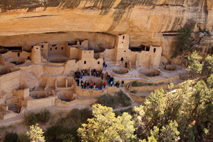
We descend the metal stairs and a short ladder to the level of the ruins, and await the ranger, a Mr. Castillo, to catch up after locking the gate above us.

Ranger Castillo is well versed in the latest archeological theories of the comings and goings of the Anasazi, now known as the Ancient Puebloans, and does a great job answering questions from the touristas. Did drought famine or warfare drive the puebloans from their cliff homes? No one is sure. Its possible that they just moved for obscure religious reasons.
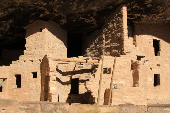
My personal theory is that they moved to avoid foreclosure after their adjusted rate mortgages reset on these cliff dwellings. And the rooms full of human bones that have been discovered near some ruins nearby? Well, those are the ancient puebloan bankers of course.

I keep my theory to myself, and examine some of the surrounding architecture, such as this classic T-shaped window or doorway.

The climb back up to the mesa top is an interesting series of wood ladders anchored in a crack in the mesas rimrock.

Back at the vehicle John and the expedition wine glass washer regale us with the tales of the dozens of tourists walking by, petting the labradogs and remarking on the Sportsmbile. Its hard to remain anonymous with a Sportsmobile. While we are there, one man asks an odd question, Is that a Mercedes? he asks. No its a Ford, I reply. Without the Ford logo on the billet grill in front, many people cant recognize the van as a Ford product. I have the urge to spray paint ITS A FORD on the front hood just to cut down on the number of questions asked about it.
After a picnic lunch we drive around to see the rest of the ruins on this part of the mesa, and are rewarded with good views down the canyons to the south.

One of the more puzzling ruins is Sun Palace, an unfinished building on the mesa top that was abandoned half way through construction.

The whole mystery of the abandonment of the dwellings is fascinating and the recent book by Craig Childs House of Rain; Tracking a Vanished Civilization Across the American Southwest goes into great detail about the subject.
http://www.amazon.com/House-Rain-Tracki ... 926&sr=1-1
We make one more stop the museum at park headquarters, and do a quick walk past the Spruce Tree House ruin.
I consider the stops in the park to be pretty crowded for this time of year, but I am amazed to see that the giant parking lot at park headquarters to be less than half full. Everything is relative, I guess.
Arriving back at the campground after a long day at 6PM, the weather has warmed up a little and the vicious wind of the night before has almost stopped. Still, its pretty chilly for the desert as we grill hamburgers for dinner.
Unfortunately, Johns rented RV is having a battery problem; the house battery appears to be dead and the generator wont start up to charge it. He decides to run the engine to see if it can charge the house battery before the nights freezing temperature sets in.
__________________
2006 Baja Tan SMB 4X4 EB50 PH 6LPSD
Mohawk Royalex Solo 14 foot canoe (light white-water)
Mad River Kevlar Explorer 17 foot canoe (flat water)
Dagger Royalex Legend 16 foot canoe (white-water)
Maravia New Wave 13.5 foot raft (fishing and white-water)
|
|
|
|
|
10-25-2009, 05:30 PM
|
#16
|
|
Senior Member
Join Date: Jun 2007
Location: Helena, Montana
Posts: 613
|
Re: Colorado Plateau Parks Tour - Fall 2009
DAY SEVEN FRIDAY
MESA VERDE NATIONAL PARK, CO TO HOVENWEEP NATIONAL MONUMENT, UT
After another freezing night, we fill up the Sportys empty freshwater tank and head for lower elevations. This morning after taking showers at the campground headquarters, we roll down from Mesa Verde and stop in Cortez for fuel and food. Cortez is a nice medium size town (it would be large town in Montana) serving the surrounding agricultural area on the Great Sage Plain. Leaving town toward the south, we pass a stand selling one of the local ag products, roasted chilis, but its on the wrong side of the road at a busy intersection, so I reluctantly keep driving.
South of town near the airport, we turn west onto the McElmo Canyon Road and head toward Hovenweep National Monument. McElmo Canyon is a beautiful mix of small farms and the occasional vineyard surrounded by slickrock walls. I didnt realize that this was another small wine producing area, so I dont know what types of wine are being produced here. Im determined to get to Hovenweep early and take a hike, so we dont stop and investigate the local vineyards.
The road passes by the old Ismay Trading Post on the Navajo Reservation and climbs out of the canyon onto the open grassland on the low mesa toward the north.
Shortly after 1PM we reach Hovenweep National Monument and its small campground. Hovenweep is a very rare unit of the national park system, one of which that the government has spent money upgrading the facilities in recent years. The national monument boasts a new visitor center built in 2001 and a very new and tidy campground. The campground has around 25 sites, but none are designed for monster class A RVs, making it small and intimate. We pull into one of the larger sites that will get some shade from the ramada with the Sporty.
The small national monument is located on the gently sloping sage-covered Cajon Mesa, just on the edge of the juniper forest. Shallow arroyos cut through the mesa top and most of the ruins are located near springs at the head of the canyons. After lunch, we decide to take the hike around Little Ruin Canyon next to the visitor center.
Hovenweep is one of the few national park units that allows dogs on their trail system, so we leash up the labradogs and start out on the trail west from the campground. Within a quarter mile, we reach the first ruin on the lip of the shallow canyon, Stronghold House.


Little Ruin Canyon is not like those big, deep canyons coming off the south side of Mesa Verde. It is much smaller and no more than about one hundred feet deep. But the impressive two to three story towers make it seem spectacular, like something out of The Lord of the rings.

Speaking of the Lord Of Rings, here is something hobbit sized, Eroded Boulder House.

On the opposite rim of the canyon is the Twin Towers.

Most of the trail is on slickrock, a gritty sandstone cap forming the canyon rim. The dogs are walking along fine most of the time, but I begin to notice that they are getting sore feet.

We reach the head of the Little Ruin Canyon at Hovenweep Castle and admire the fine stonework that went into constructing Square Tower some 700 plus years ago.

The dogs are definitely getting worn out from the slickrock, so we decide to head back via the visitor center and the road to the campground.
In contrast to the last three windy and cold evenings, it is warm (in the 60s) and fairly still. I grill four pork sirloins with southwestern spices (cumin and chili powder) along with a couple of fresh green chilies. The expedition wine glass washer creates an excellent coleslaw with apple cider vinegar and sweet red peppers for a side dish, as the colors begin to change at sunset over Sleeping Ute Mountain to the east. The view from the Sportsmobiles front penthouse window is stunning.

Unfortunately, the weather report we noticed at the park visitor center may be correct for another freezing night, and the temperature begins to drop like a rock. By bedtime, it is in the mid 40s and headed down, so I reluctantly empty the Sportys freshwater tank again to prevent freezing as the moon rises to the east.

__________________
2006 Baja Tan SMB 4X4 EB50 PH 6LPSD
Mohawk Royalex Solo 14 foot canoe (light white-water)
Mad River Kevlar Explorer 17 foot canoe (flat water)
Dagger Royalex Legend 16 foot canoe (white-water)
Maravia New Wave 13.5 foot raft (fishing and white-water)
|
|
|
|
|
10-28-2009, 06:47 AM
|
#17
|
|
Senior Member
Join Date: Jun 2007
Location: Helena, Montana
Posts: 613
|
Re: Colorado Plateau Parks Tour - Fall 2009
DAY EIGHT SATURDAY
HOVENWEEP NATIONAL MONUMENT, UT TO NAVAJO NATIONAL MONUMENT, AZ
Its 34 degrees F when I get up to walk the dogs before dawn, but it is warming up fast. The nearly full moon with clear skies last night was beautiful, lighting up the surrounding landscape and giving me almost enough light to read a book in the SMB penthouse without turning on a light.
The warm still morning finally allows me to cook the thick sliced bacon outside weve been carrying around since Palisade, Colorado, without greasing up the interior of the Sportsmobile. I get a wood and charcoal fire going in the fire grate while the Expedition Photographer makes buckwheat pancakes inside the Sporty.

After a leisurely breakfast outside under the ramada, we decide to split up for the day, with the rented RV folks going up to Blanding, Utah to visit the Edge of the Cedars State Park and museum, while we explore the rest of Hovenweep some more, before meeting at Navajo National Monument for the evening. We have been to Edge of the Cedars several times, and it has one of the best collections of Ancient Puebloan pots and crafts in the entire Southwest.
Before we can drive up to the units of Hovenweep NM, we have to stop at the visitor center for a map and directions. The Park Service doesnt hand the maps of the other units out without telling visitors how to find them by vehicle and on foot. We are going up to next unit to the north, containing three areas of ruins, two of which accessible from a short hike. We drive north for ten miles and turn east onto a sandy rocky road. After two more miles, we park and get ready to hike to the Horseshoe and Hackberry ruins.
Its another interesting slickrock trail following the rim of a couple of shallow canyons and the labradogs seem to be doing well with their sore paws from yesterday. Horseshoe turns out to be another circular tower overlooking the canyon, with incredibly detailed rock and mortar work.


The ancient stone masons used smaller rocks to fill in chinks in the mortar, and possibly to give it a more decorative look. On the trail to Hackberry, we pass a good example of the cryptogamic soil (a mixture of bacteria and blue-green algae) under the Pinyon Pines.

Hackberry Ruin is a rectangle tower set in the Pinyon Pine Forest.

It is starting to get really warm in the sun, and we hike back to the Sporty to water the labradogs, before driving over to Holly Ruin. It takes a little four wheeling to get the last hundred yards to Holly, but we decide not to get out and hike again in the heat. Now its time to head southwest toward the San Juan River.
We decide to have lunch at the Sand Island BLM Campground on the San Juan River, the start for many of the river trips along this stretch of water. We havent been here since 1986 when we floated the San Juan in our inflatable kayaks.

I have to carefully keep the labradogs on leash while on the boat ramp, to prevent them from swimming out into the strong current and starting a river trip of their own without a permit.
There are two other Sportsmobilers having lunch here, Tom and Lynn from Anchorage Alaska. The two gentlemen are ferrying their rigs down to Phoenix for the winter season. One of the guys bought his rig used in Florida earlier in the year, drove it home to Anchorage, and is now driving to Arizona. Thats a heck of a lot of mileage in one year!

The labradogs rest in the shade of the picnic table while we have lunch.

Back in the Sporty, we drive through the spectacular canyon scenery around Mexican Hat and up into Monument Valley on the Navajo Reservation. Its another three hours to Navajo National Monument without stopping. There is too much to see and too little time.
We pull into the small campground at Navajo NM at 4:30PM. The campground is half full and it is cool and windy again at this 6,000 foot altitude. The Expedition Photographer cooks pasta with Italian sausage for dinner as the rented RV folks catch up and grab a campsite.
Walking around the campground while dinner is cooking, I watch the incredible sunset off of the west rim of the mesa, as the sun goes down amid black storm clouds. Another big cold front is moving in and the desert smells like rain.
__________________
2006 Baja Tan SMB 4X4 EB50 PH 6LPSD
Mohawk Royalex Solo 14 foot canoe (light white-water)
Mad River Kevlar Explorer 17 foot canoe (flat water)
Dagger Royalex Legend 16 foot canoe (white-water)
Maravia New Wave 13.5 foot raft (fishing and white-water)
|
|
|
|
|
10-30-2009, 06:35 AM
|
#18
|
|
Senior Member
Join Date: Jun 2007
Location: Helena, Montana
Posts: 613
|
Re: Colorado Plateau Parks Tour - Fall 2009
DAY NINE SUNDAY
NAVAJO NATIONAL MONUMENT, AZ TO PAGE. AZ
Im greeted by a cool and breezy morning walking the labradogs before sunrise around the small campground. The yellow labradog is reluctant to do her business without any green grass to be found under the juniper trees surrounding the campsite, so we walk further over toward the visitor center on the trail. Directly ahead of us a small coyote runs onto the trail and takes a dump, before scampering off. Obviously, this canine cousin doesnt have any problems with the lack of grass.
After breakfast we return to the small visitor center which features a nice collection of puebloan artifacts and a Navajo woman weaving a rug using plant based dyes. The trail to the Betakin ruin starts out the back door of the visitor center. Its an odd trail made of concrete poured over huge slabs of sloping slickrock, and leads to a small overlook.

The Betakin ruin is in a large alcove a quarter mile away across Tsegi Canyon.

Its hard to see much detail of this cliff dwelling from this distance, but you can sign up for ranger guided tours at some times that go directly to the ruin via the trail in the canyon bottom.

It would be nice to spend more time checking out the changing light along Tsegi Canyon, but we need to pack up and get down the road to Page, Arizona.

Just before we leave, a large group of motorcyclists from Germany pull in and do a quick tour of the visitor center and tourist trail. They are visiting national parks around the Colorado Plateau followed by their sag wagon, a small van, and staying in motels. I wonder how many Americans have the vacation time to tour national parks throughout Europe. Not many I would think, since Americans work more and take less vacation time off than any other country other than Japan.
The Expedition Photographer takes over the driving for this short stretch downhill and across the mesas to Page. Back on US 160 for a few miles, the highway parallels the Black Mesa and Page Railroad line, a railroad that transports coal from the local strip mines to the Navajo Generating Station at Page. The train is electric powered from overhead lines, using electricity from the generating station, an interesting setup.
We turn northwest off of US160 onto Navajo 98, and what was a steady headwind is now a vicious crosswind. This could be a scenic drive, but we cant see much with the amount of dust blown up by the increasingly strong wind. The Sporty handles the heavy crosswinds pretty well, but the folks in the rental RV have a much harder time of it staying on the road.
After several miles, we catch up to the German motorcyclists pulled over next to their sag wagon taking a break from the dust storm. How these poor people ride bikes safely in this nasty weather is beyond me.
Finally, the tall stacks of the Navajo Generating Station come into view over the horizon as we reach the outskirts of Page. We have reserved a couple of spots at the local RV park so that the rental RVs electrical problems can be checked out before heading back out into the sticks on the North Rim of the Grand Canyon. Pulling into the RV park at 1:30PM, I immediately begin having second thoughts. The wind is still roaring with gusts up to 50mph plus, and the campsites are awash in heavy windblown dust. Theres no place to walk the dogs and Im concerned about even putting the penthouse top up in this sort of wind. To make it worse, we get assigned to a spot that some idiot is still parked in, even though checkout time was 11AM. Finally he moves out and we park and reconnoiter.
The rental RV folks get plugged in and have shore power, but we decide to bail and find a motel to get out of the dust and wind. Driving around Page, we find a Best Western that even has green grass surrounding the motel, a real treat for the yellow labradog.
We spend the rest of the day washing clothes, getting take out from a local Mexican restaurant, and examining the view of Glen Canyon Dam from our motel window.

__________________
2006 Baja Tan SMB 4X4 EB50 PH 6LPSD
Mohawk Royalex Solo 14 foot canoe (light white-water)
Mad River Kevlar Explorer 17 foot canoe (flat water)
Dagger Royalex Legend 16 foot canoe (white-water)
Maravia New Wave 13.5 foot raft (fishing and white-water)
|
|
|
|
|
10-30-2009, 07:45 AM
|
#19
|
|
Senior Member
Join Date: Feb 2009
Location: France, Europe
Posts: 617
|
Re: Colorado Plateau Parks Tour - Fall 2009
Quote:
|
I wonder how many Americans have the vacation time to tour national parks throughout Europe.
|
The French and Germans work 35 hours a week, but of course they have a system that allows them to work more hours a week and then recuperate the overtime in holidays... this is probably why they have more time...
How many weeks does the average American citizen take per year?
Great report love the photos 
__________________
New ride: 2000 Chevy Suburban 1500 4WD
1998 Chevy Express 2500 past project
+ 1990 Mitsubishi Pajero V6 3.0l
+ 2001 Saab 9-5 Aero Hirsch
+ 1972 Saab 96 V4 (not running)
+ fixed house (Argh)
|
|
|
|
|
10-30-2009, 07:55 AM
|
#20
|
|
Senior Member
Join Date: Jun 2007
Location: Helena, Montana
Posts: 613
|
Re: Colorado Plateau Parks Tour - Fall 2009
Thanks Saabman!
Americans take less than two weeks (ten business days) for vacation on average each year. A lot of people get a bit more, but never take it. It is a workaholic society encouraged by corporations that take advantage of a non-unionized work force. The United States, aside from being the only developed country without a national health care system, is one of the few developed countries without a minimum amount of required annual vacation time. Don't get me going too much on this issue; it's one of my favorite rants!
As a professional geographer and a Sportsmobile owner, I feel that I am required to take a lot of vacation and explore geography.
__________________
2006 Baja Tan SMB 4X4 EB50 PH 6LPSD
Mohawk Royalex Solo 14 foot canoe (light white-water)
Mad River Kevlar Explorer 17 foot canoe (flat water)
Dagger Royalex Legend 16 foot canoe (white-water)
Maravia New Wave 13.5 foot raft (fishing and white-water)
|
|
|
|
|
|
 Posting Rules
|
You may not post new threads
You may not post replies
You may not post attachments
You may not edit your posts
HTML code is Off
|
|
|
|
 » Recent Threads
 |
|
|
|
|
|
|
|
|
|
|
|
|
|
|
|
|
|
|
|
|
|
|
|
|
|
|
|
|
|
|
|
|
|


 Linear Mode