Just got back from six days at Parashant. Well worth the drive!
My wife and I usually travel alone and this trip was no exception. We knew we would often be 60 miles from pavement and further away from help. We have an inReach satellite communicator an amazing device I highly recommend which both satisfies our family that we re safe and allows us a way to communicate in an emergency when cell signals are wishful thinking.
For navigation inReach has what I think is a great map application, Earthmate. Just download the map for Arizona and youre good to go. I also downloaded the Arizona Strip Map from BLM,
https://www.blm.gov/basic/maps-avenza-arizona which works with the Avenza map app. Both apps have detailed maps of Parashant and I switched back and forth between them. It was great to get another opinion if I was in doubt. I also bought a paper copy of the BLM map in the St. George ranger office.
We wound up driving 350 miles on dirt, about 250 of which were very nicely graded, maybe 90 were 4WD and 10 or so were 4WD low range. The distances were long so fuel management was an issue. We drove 300 miles on dirt before we resupplied. At that point I estimate we had maybe 80 miles range left between the tank and my one fuel can. For safetys sake that felt right to me most everywhere is 60 miles from a gas station and if you get up some canyon it is easy to have to backtrack 20 miles.
We entered 5 miles east of Pipe Spring national Monument. Theres a gas station at Pipe Spring so top up your tank there. We also got a nice tour of the Windsor Castle a Mormon fort from the 1870s. The park rangers told a story of western clashes with native Americans and the impact of overgrazing on the environment.
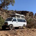
Our first stop was Toroweep Campground , 60 miles down a dirt road from Hwy 389. I aired down to 35 front and 45 rear, my standard dirt road air pressure. The first 57 miles are some of the best dirt roads Ive driven on (Roads 109 and 115). The last 3 miles are only mild 4WD. The reward is an amazing vista of the Grand Canyon with a sheer 3,000 foot drop to the Colorado River below. You must get a permit before you travel there and it is a bit of a hassle. We chose to go to the BLM office in St. George and it took about an hour to get it. There are 10 camp spots and it was mid-week
and its 60 miles down a dirt road
so I thought the odds were good.
The next day we drove up to a Pinyon Pine forest at 6,000 feet. The roads were mild dirt (Roads 115 and 5. We stopped at Nampaweap, a canyon with many pictographs and took a nice hike and lunch there.
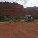
That morning we broke camp and drove down a cut bench, toured an old Mormon school house and then drove out to Twin Point another highlight (Road 5, 103). There are two roads in to Twin Point direct and relatively good and twice as long and much rougher. We took that one. We drove down Pidgeon Canyon (1002) which had wonderful geology and plants. At the tail end of 32 mile dirt bumpy road we ran into our first 4WD low range section a short, steep, uphill, narrow rocky stretch around a turn (1012). Enough to get your attention but nothing really serious.
Twin Point is then another 12 miles of mostly mild/bouncy dirt (1019). We were the only ones camped on this peninsula on a Friday night and we saw nobody on Saturday as we drove out. The views are amazing and there are many short hikes to still more amazing vistas.
Saturday afternoon and Sunday morning we drove the toughest sections. I had carefully quizzed the BLM staff on road conditions. I had told them I wanted to enter at Pipe Springs and then cross over to Mesquite a trip they called ambitious. They warned me of one section, not long but with rocky drop-offs (1003). The rangers said, going east to west, we would be going downhill so it would be manageable for a vehicle our size. The road before and after that part turned out to be 10 miles of low-range 4WD and the drop they warned me of was, in fact, the only part I got out to scout, place some rocks and have my wife spot my tires as I descended. It was uneventful. I can see that going uphill would be a challenge. I probably would have lowered my air pressure as much as I dared but I think our Sportsmobiles could have made it uphill as well. I would definitely recommend at least one lead short-wheelbase modified vehicle to pull you up if there were to be a problem theres no room to turn around and it would be a very ugly hill to back down.
There is an absolutely drop-dead gorgeous informal campsite just east of this hard section. We enjoyed a wonderful evening there and you should too.
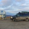
After descending the rocky section we were low on fuel and so headed 30 miles over a mix of great/mild/low-range dirt roads (1027 and 242) to Mesquite NV where we refueled and resupplied.
We finished our trip with another 100 mile trip down 40 miles of badly paved road and 60 miles of dirt to two desert springs, Tassi Ranch and Pakoon Springs and we camped within sight of Lake Mead (113, 1213, and 111).
The BLM recommends travelling with two spare tires. My rig is set up that way normally. I did injure the sidewalls of both rear tires, enough that I will retire them to spares and get some new ones. There are a lot of rocks and I can easily see losing a tire or two. There is not a lot of soft sand so I never felt the need to lower my tire pressure for that.
There were a lot of roads that were said to be jeep-only or UTV-only which I did not attempt. Being alone has its limits. Everything I attempted was well within the limits of the Sportsmobile. I was never close to stuck and never tempted to use my locker.


 Sportsmobeebs, Sporty for short
 2008 GMC 3500 SMB
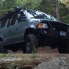 AWOL
AWOL

 Linear Mode