|
|
 01-25-2016, 04:41 PM
|
#11
|
|
Senior Member
Join Date: May 2007
Location: East Bay CA
Posts: 1,078
|
Quote:
Originally Posted by Pschitt

I agree, espacially if you're exploring remote places...  |
I disagree.
USGS maps are often out of date. And lack features that other more up to date maps have. It depends on the area, but USGS maps especially lag in areas like national forests. USFS topos in many areas have been updated much more recently, and are better in many cases at showing current open vs closed roads, road numbers, etc.
Other maps, like Harrisons and the Nat Geo ones, show points of interest that the gov't maps ignore. And are often much better for trails. Sometimes Open Hiking Map or Open Street Map are better (definitely the case where I live in the SF Bay Area).
And it depends on scale as well; the 7.5' topos aren't too bad, but above that you need some thoughtful editing to make the maps useful; I like the Benchmark atlases for those.
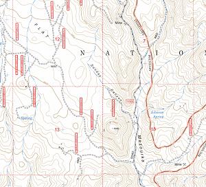
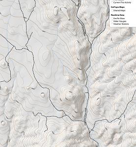
Here are three examples of the area in the Owens Valley near Mazourka Canyon, a popular SMBish trip. USFS at the top, then USGS, then Mapbuilder.

__________________
2001 Ford E250 Sportsmobile with Salem-Kroger 4x4 conversion
|

|

|
|
01-25-2016, 06:46 PM
|
#12
|
|
Senior Member
Join Date: Apr 2014
Posts: 162
|
If you want a good digital map you can look at California Trail Maps California Trail Map
It is available for Garmin, Lowrance, iPhone and Android. For $44.99 you can get lifetime updates forall. I started when it just covered San Diego and Imperial counties and they have been steadily expanding Northward. They just recently added Death Valley. I have it installed on my Samsung Galaxy and my Garmin Montana. It has updated trails.
It's well worth a look.
__________________
Chris/Bev
2012 E350 EB50 V10 Cruiser Top
Sportsmobile 4WD Conversion
|
|
|
|
|
01-26-2016, 12:39 AM
|
#13
|
|
Senior Member
Join Date: Nov 2012
Location: Switzerland
Posts: 1,018
|
Quote:
Originally Posted by rob_gendreau
I disagree.
USGS maps are often out of date. And lack features that other more up to date maps have. It depends on the area, but USGS maps especially lag in areas like national forests. USFS topos in many areas have been updated much more recently, and are better in many cases at showing current open vs closed roads, road numbers, etc.
|
Well, with Gaia GPS, you don't only have USGS but many other maps like USFS, Map Quest, Open Hiking Map, World Imagery, etc. I espacially like the last one since you can see the kind of terrain you're going to travel in. And you can add other maps if you want.
However, the best map is always a mix of several, for me at least.
Since I usually prepare my trips in advance, I don't need POIs integrated to the map, I insert those I wanna see in Gaia, thus I can be routed to by the apps.
__________________
Travelling in VivaLaVida (custom 2010 6.0 Ford E-350 Extended with U-Joint 4WD conversion)
|
|
|
|
|
01-26-2016, 09:32 AM
|
#14
|
|
Senior Member
Join Date: May 2007
Location: East Bay CA
Posts: 1,078
|
Quote:
Originally Posted by Pschitt
Well, with Gaia GPS, you don't only have USGS but many other maps like USFS, Map Quest, Open Hiking Map, World Imagery, etc. I espacially like the last one since you can see the kind of terrain you're going to travel in. And you can add other maps if you want.
However, the best map is always a mix of several, for me at least.
Since I usually prepare my trips in advance, I don't need POIs integrated to the map, I insert those I wanna see in Gaia, thus I can be routed to by the apps.
|
That's why it's my favorite.
And BTW, in some areas my favorite maps to use are the very old topos that you can load in Gaia GPS (or see in caltopo.com). The old ones often have features that have since disappeared from the modern maps, and give hints to old mines, roads, trails, etc that can be fun to explore.
__________________
2001 Ford E250 Sportsmobile with Salem-Kroger 4x4 conversion
|
|
|
|
|
01-27-2016, 12:10 AM
|
#15
|
|
Senior Member
Join Date: Apr 2007
Location: Seattle, WA
Posts: 1,061
|
Quote:
Originally Posted by Pschitt
Take a look at Gaia GPS app. about 20$$ and you can download avery topographic maps for free... ;-)
|
If you're running Windows (I'm now switching to using a Microsoft Surface), Mapsphere is looking pretty good, with unlimited downloads of Bing maps satellite imagery. I'm going to try this on my next Baja trip -- where there are plenty of roads that appear on no maps at all.
-- Geoff
|
|
|
|
|
01-27-2016, 12:08 PM
|
#16
|
|
Site Team
Join Date: Jun 2011
Location: Santa Fe, NM
Posts: 1,202
|
A dedicated GaiaGPS user here, recognizing that you need to download maps in advance for non-cellular areas. As Rod says, the older maps (i.e., 1918-ish) are fun for bushwhack exploring. And, it gives you a wide selection of other map sources for variety. Its tracking works well and you can share maps, trails, photos and waypoints among multiple devices with the pro account. Not to mention public sharing, if you're into that. It also has an interesting feature to map a route between two points with no existing trail but following contours and the terrain.
However, just as I doubt few people on this forum have only one screwdriver, I like multiple maps, including the variations on Trails Illustrated; the USGS downloads (especially because you can choose your areas rather than be limited to a collection of 7.5s), and well-written field guides. (Not necessarily talking about trail guides but books like The Eastern San Juan Mountains: Their Geology, Ecology, and Human History.
WRT 7.5s, has anyone noticed it always takes four maps to cover the place you want because that place is in the corner of all four?
Don
__________________
-Don-
Life and baseball both sometimes are not fair, but it is how you play the hops that counts. Scott Miller, NYT Sports
|
|
|
|
|
|
| Thread Tools |
|
|
| Display Modes |
 Linear Mode Linear Mode
|
 Posting Rules
|
You may not post new threads
You may not post replies
You may not post attachments
You may not edit your posts
HTML code is Off
|
|
|
|
 » Recent Threads
 |
|
|
|
|
|
|
|
|
|
|
|
|
|
|
|
|
|
|
|
|
|
|
|
|
|
|
|
|
|
|
|
|
|


 VivaLaVida
 Adobe Loon (aka the Dawghaus)