|
 01-25-2023, 12:48 PM
|
#1
|
|
Member
Join Date: Feb 2020
Location: PNW
Posts: 78
|
Arizona/Utah trip in March/April
Hi all! I'm headed down to northern AZ and southern Utah from mid-March to early April, and am in the early planning stages of where to go, what to do... I (we) intend to hover within the geofence perimeter of Coyote Buttes for some of it, in order to secure a permit for the wave et al., but am also open to anything else. I do not have floating axles and want to avoid super gnarly rock crawling, and want to avoid people as much as possible. Any input, advice, and recommendations are greatly appreciated!
|

|

|
|
01-25-2023, 01:29 PM
|
#2
|
|
Senior Member
Join Date: Apr 2018
Location: West Central Mountains, Idaho
Posts: 479
|
Quote:
Originally Posted by PNWschusser

I do not have floating axles and want to avoid super gnarly rock crawling, and want to avoid people as much as possible
|
Keying in on your wanting to avoid people as much as possible and wanting to explore Northern Arizona. Consider checking out the Shivwits Plateau, Mount Dellenbaugh and Mount Trumbull Wilderness areas. If you go, make sure to have an alternative form of communication such as an InReach device. That area is mostly administered by Arizona Strip BLM and Lake Mead NRA. I used to work at Lake Mead and enjoyed my time on the "Plateau".
Cheers!
__________________
2001 Sportsmobile RB50 7.3
West Central Mountains, Idaho
|
|
|
|
|
01-25-2023, 01:37 PM
|
#3
|
|
Member
Join Date: Feb 2020
Location: PNW
Posts: 78
|
Quote:
Originally Posted by Steve C
Keying in on your wanting to avoid people as much as possible and wanting to explore Northern Arizona. Consider checking out the Shivwits Plateau, Mount Dellenbaugh and Mount Trumbull Wilderness areas. If you go, make sure to have an alternative form of communication such as an InReach device. That area is mostly administered by Arizona Strip BLM and Lake Mead NRA. I used to work at Lake Mead and enjoyed my time on the "Plateau".
Cheers!
|
Great, thanks! And yes, I have a Garmin Montana 700i, which has been incredibly useful thus far.
|
|
|
|
|
01-26-2023, 10:21 AM
|
#4
|
|
Senior Member
Join Date: Jul 2011
Location: Flagstaff, AZ
Posts: 2,001
|
Mid-March is going to be tough at elevation in northern Arizona. Snowpack is 200-300% of normal. That rules out the much of the North Rim.
__________________
2005 E350 RB 6.0 PSD for extended fun
1989 Landcruiser FJ62 for local fun
2011 VW TDI Golf for hwy fun
|
|
|
|
|
01-27-2023, 12:03 PM
|
#5
|
|
Senior Member
Join Date: Jan 2012
Location: Middle of Nevada
Posts: 303
|
Quote:
Originally Posted by JoeH
Mid-March is going to be tough at elevation in northern Arizona. Snowpack is 200-300% of normal. That rules out the much of the North Rim.
|
^This!
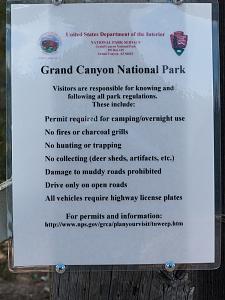
I've explored the Arizona Strip extensively through the years. Elevation is about 6,000 feet and higher and there's areas I've not been able to explore in mid-May because of mud and snow. Bottomless, sticky clay mud that will turn any tire into slicks. People get really unhappy if you put deep ruts in the roads. Sign about 70 miles south of Fredonia:
__________________
Worshipper of Wild Country
2007 Quigley V-10 on 33s with 4.56 gears (Toyhauler)
|
|
|
|
|
01-30-2023, 03:22 PM
|
#6
|
|
Member
Join Date: Feb 2020
Location: PNW
Posts: 78
|
Quote:
Originally Posted by deserteagle56
^This!
I've explored the Arizona Strip extensively through the years. Elevation is about 6,000 feet and higher and there's areas I've not been able to explore in mid-May because of mud and snow. Bottomless, sticky clay mud that will turn any tire into slicks. People get really unhappy if you put deep ruts in the roads. Sign about 70 miles south of Fredonia:
Attachment 46337 |
Ugh! Ok. I thought I had done enough research on the weather, but apparently not. Will figure out an alternative. Thanks all!
|
|
|
|
|
02-02-2023, 10:31 AM
|
#7
|
|
Member
Join Date: Nov 2014
Posts: 89
|
Good luck in getting a permit for The Wave. I was fortunate enough to secure one in March of 2009 after only spending two days in the Kanob BLM office. Since then it has become much more difficult to get a permit. I had some friends who spent 5 days in the BLM office a couple of years ago and never got a permit. Coyote Buttes South has similar formations but the road in has deep sand and sharp rocks and requires 4WD.
Jim
|
|
|
|
|
02-02-2023, 11:53 AM
|
#8
|
|
Senior Member
Join Date: Jan 2009
Location: Boulder, CO.
Posts: 2,554
|
If conditions allow, further in on house rock rd theres White Pocket, an equally impressive formation thats harder to get to due to deep sand, so less visited and you dont need a permit, we aired down and didnt have any issues. Theres some great camping spots along the way.
Ill see if I can dig up some more info on the area from when we were there.
__________________
'03 Ford E350 7.3L Diesel
(de)SMB'd Custom RB-50
Quigley 4X4 w/Deavers & Agile Offroad's R.I.P. package
CCV High Profile Pop Top
|
|
|
|
|
02-03-2023, 08:37 AM
|
#9
|
|
Senior Member
Join Date: Jul 2011
Location: TN
Posts: 10,244
|
I had a great solo trip to this area last year about this time but they had a much milder winter. Be very careful around the Arizona strip. If you think 'I'm ok, I'm 4wd' then go watch some Matt's Offroad videos on Youtube lately of his recoveries there. That mud can be awful. White Pocket is amazing but the main road in (House Rock Rd.) might be impassable. Another sweet area is just north of there, Cottonwood Canyon area up to Burr Trail area (I can't remember what that area is called but it has another name). Anyway, beware of the mud.
Thanks for the recommendations Steve C. I love that general area and may push further west towards Lake Mead on your recommendation next time I'm out there.
|
|
|
|
|
02-03-2023, 06:10 PM
|
#10
|
|
Senior Member
Join Date: Jul 2011
Location: Flagstaff, AZ
Posts: 2,001
|
There is or was snow down to 5000' across much of northern arizona but Feb has brought high pressure and warmer temps. Should be good to go wrt the Wave or White Pocket here soon. N. Rim won't be open until May but you can get in from the west side on forest service roads. Probably by April on that unless March roars in like a lion.
It looks like back to a La Nina type hemispheric pattern for much of the southwest through at least February. That means cold and dry.
__________________
2005 E350 RB 6.0 PSD for extended fun
1989 Landcruiser FJ62 for local fun
2011 VW TDI Golf for hwy fun
|
|
|
|
|
 Posting Rules
|
You may not post new threads
You may not post replies
You may not post attachments
You may not edit your posts
HTML code is Off
|
|
|
|
 » Recent Threads
 |
|
|
|
|
|
|
|
|
|
|
|
|
|
|
|
|
|
|
|
|
|
|
|
|
|
|
|
|
|
|
|
|
|


 Ford Zilla


 Linear Mode