Part 3
The next morning we continued south toward Hole-in-the-Rock but we only got a few miles. After a heated discussion on the wisdom of continuing..we turned around. Sherri was sure that we not to the 4WD section yet. I was driving up 30% rocky grades in 4LO out of the gulches. I was pretty sure we were already in the worst of it. I've seen pictures of unmodified SUVs and 4x4 pickups at the end of the road.
Anyhow... we turned around and headed north to Capitol Reef. It took most of the day to drive out to the highway. We turned up Hwy 12 toward Boulder and stopped about a dozen miles up the road at Calf Creek Campground. (37.795976,-111.413114)

Summer and Eddy on the trail to Calf Cr. Falls

The next morning, Sun. Nov 3, we continued north to Boulder and had a great but SLOW homecooked breakfast in the cafe. They let up re-fill our water tank from their spigot and we were on on way east down the Burr Trail. The road up Long Canyon is world class beautiful but coming up on a cattle drive made it even more so.

After a minute or so, one of the cowboys dropped back and told us we could come through the herd slowly.

At the edge of Capitol Reef, just 1/4 mi before the road drops down the Burr Trial switchbacks, we turned left - north- up Muley Twist Canyon. This is the only 4WD track in the park and runs up the canyon bottom about 3 miles to the trail to Strike Valley Overlook.
Here are some views from the overlook...
Looking east across the Waterpocket Fold to the Henry Mts.

Looking north up Waterpocket Fold with Capitol Reef on the left.

Looking south down Waterpocket toward the Colorado R.

Some photos from the way back down Muley Twist Canyon.

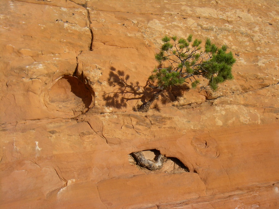
One very tough tree.
Peak-a-boo Rock


Yet another rock with a hole in it.

We continued out and down the Burr switchbacks. We turned south on the Notom-Bullfrog road intending to take the ferry across the river at Bullfrog. More on that later...
That night we camped again just off the road. (37.776557,-110.941832)


Next morning as we started out toward Bullfrog, I noticed a place on the map called Eggnog. Only 5 miles out of our way and with a name like that, we had to check it out. Turned out to be just a stucco ranch house. Only structure within 20 miles.
On the way in, we took no notice of this little canyon on the side of the road. It was facing away from us.

The view on the way back showed this classic box canyon corral.

Back at the Notom-Bullfrog road, looking toward the river.

The ferry at Bullfrog shuts down on Nov 1. We'd sort of expected that but it was only a few miles out of our way to find out for sure.
So we went back up river to cross at Hite and drive up White Canyon.
Took a couple of walks in the slickrock

We stopped at this Historical Marker. This odd sign was made by writing with a welding rod. I had to tweak the contrast and gamma to make it 1/2 way readable which is why the background looks odd.


In the afternoon we turned south up Fry Canyon. We went up Radium King Rd - which is in the background - and turned south on an old road into Tables of the Sun. Great views. Found an interesting but unreachable midden in a large crack in the rocks. Probably from the 50s mining boom. Steel beer cans, steel band twist open coffee cans, etc. The hillside where this was taken had a huge amount of petrified wood eroding out of it.

In the morning we went back to Hwy 95 and drove east to Blanding. We stopped there to do laundry, grocery resupply, fuel and a restaurant lunch. From there it was north toward Moab, turning off a LaSal Junction to visit a friend in Paradox Valley, Co.
I'll continue with that in Part 4...


 VivaLaVida
 Linear Mode