Journey with Confidence RV GPS App RV Trip Planner RV LIFE Campground Reviews RV Maintenance Take a Speed Test Free 7 Day Trial ×


Reply
 
Thread Tools Display Modes
 
Old 05-11-2010, 01:17 PM   #21
Senior Member
 
pjpvi's Avatar
 
Join Date: Apr 2007
Location: SF Bay Area, CA
Posts: 1,289
Re: Mammoth/395 Trip Help Planning Mid May Update 29 April

Quote:
Instead of camping in the Alabama Hills try Santa Rosa Flat off Mazurka Canyon out of Independance.

Great views of the Sierra Nevada. The weather in the Inyos should be warmer and drier than under the Sierra.

then 4wd up to Papoose Flat, down to Squaw Flat, thru Upper Marble Canyon and out to the Eureka/Saline road and back to Big Pine.

If you do go to the Alabama Hills dont miss the Stone House at the base of Tuttle Creek, the last mile of road is 4wd then about a 3/4 mile hike but its worth it.

Id say the highest place with a view of the Sierra Nevada you can drive to would be the end of the road to Barcroft Station in the White Mountains. (Up Silver Canyon out of Laws, down Wyman Canyon into Deep Springs Valley.
Jstanley -

I'm thinking of taking your recommendation of up Mazurka Canyon and ultimately out Eureka/Saline Road. In looking over some maps, it looks like there are some missing connectors up top. Will the trails be obvious up there?

Of course, with the weather lately, there may be way too much snow up that high. If things look too white, we may just peel off and head into Death Valley directly instead. Playing this trip a little by ear.

Phil

__________________
Phil

- 2005 EB50 6.0PSD - SMB 4x4
pjpvi is offline   Reply With Quote
Old 05-12-2010, 08:59 AM   #22
Senior Member
 
jstanley's Avatar
 
Join Date: Jul 2009
Posts: 138
Re: Mammoth/395 Trip Help Planning Mid May Update 29 April

Quote:
I'm thinking of taking your recommendation of up Mazurka Canyon and ultimately out Eureka/Saline Road. In looking over some maps, it looks like there are some missing connectors up top. Will the trails be obvious up there?
Get an Inyo National Forest map, that should show all the connectors. Be aware there are a lot of new areas of Wilderness designation, many roads are closed but the main ones do go thru.

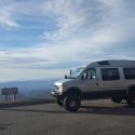
Up Mazurka to Badger Flat. 4wd from Badger to Papoose flat (excellent place to camp). Papoose Flat to Squaw Flat. Down out of Squaw Flat via Marble canyon, out to the Eureka/Saline Valley Road.

Good deer and chukar hunting, and lots of artifacts, mining and prehistoric. Be careful of the mineshafts.

I would advise getting out of Squaw Flat via Marble Canyon NOT the Hinds road west of Andrews Mnt.
I would also advise against the Papoose Flat strait down to Harkless Flat route, easy but now closed.

Best hike in the area is Barrel Spring to Winneduma Paiute Monument out of Mazurka Canyon.
jstanley is offline   Reply With Quote
Reply


Posting Rules
You may not post new threads
You may not post replies
You may not post attachments
You may not edit your posts

BB code is On
Smilies are On
[IMG] code is On
HTML code is Off
Trackbacks are Off
Pingbacks are Off
Refbacks are Off

» Featured Campgrounds

Reviews provided by

Powered by vBadvanced CMPS v3.2.3
Disclaimer:

This website is not affiliated with or endorsed by Sportsmobile SIP or any of its affiliates. This is an independent, unofficial site.


All times are GMT -6. The time now is 01:17 AM.


Powered by vBulletin® Version 3.8.8 Beta 4
Copyright ©2000 - 2024, vBulletin Solutions, Inc.