Journey with Confidence RV GPS App RV Trip Planner RV LIFE Campground Reviews RV Maintenance Take a Speed Test Free 7 Day Trial ×


Reply
 
Thread Tools Display Modes
 
Old 11-15-2020, 03:29 PM   #1
Senior Member
 
Join Date: May 2017
Posts: 201
Southern Idaho Roadtrip

We took another Covid summer trip. We avoided people as we kayaked the Snake River, hiked to hot springs and enjoyed the beauty of southern Idaho.

There will be a lot of pictures.

Our destination for the first night was McClendon Springs, a primitive campsite about 30-40 miles into Idaho. The springs were a key stopping point on the California Trail and is known as “The Oasis in the Desert”. We were the only ones at the springs and it was a nice warm night as we explored the trails through the area. The night was very quiet and peaceful.


We woke up early in the morning so we could drive the 1-1/2 hours to Twin Falls. The plan for the day was to kayak up the Snake River to the Pillar Falls and then on to Shoshone Falls. We wanted to get somewhat of an early start to avoid the afternoon winds.


We arrived at Centennial Park, on the Snake River. The park is on the north side of Twin Falls. To get to the part you have to drive down into the gorge on a narrow switchback that ends at the waterfront. It is a very nice park with grassy areas, restrooms and picnic pavilions. The water front has several docks, including a roller launch dock. You just put the kayak on the rollers, sit in the kayak and push yourself into the water. This was a lot easier than getting in from the dock.


We were on the water at 10:40 am and started paddling upstream. After about a mile, around the first bend in the river, we passed under the Perrine Memorial Bridge. This bridge is 1,499 feet long and is 486 feet above the Snake River. This is the only bridge in the US that allows BASE jumpers to parachute off the bridge. Unfortunately, we didn’t see anyone jump. We heard that the day before, 20-30 jumpers were on the bridge.


Paddling up the current wasn’t too bad, but if you stopped paddling, it wasn’t long before you started going backwards. Another mile or so past the bridge, we arrived at Pillar Falls. These falls flow through limestone pillars and shelves as it drops about 28 feet to the river. We beached our kayak on the right side of the river and carried the kayak around the falls, through the trees and rocks. If the river running high, the water can be flowing a foot or two deep on this 300 yard trail. But fortunately, it was dry for our passage.


Once we were above the falls, we launched the kayak back into the river and continued our upstream paddle to Shoshone Falls. Many of the kayakers and paddle boarders stop at Pillar Falls and the motorized boats have no way to continue upstream, so this section of river is much calmer and quieter. We saw ducks and other waterfowl on both sides of the river. It is about a 1-1/2 mile paddle to the base of Shoshone Falls.

Shoshone Falls is known as the Niagara of the West. It is actually 45 feet higher than Niagara at 212 feet high, but the water flow is less than Niagara. On this day the water flow was on the low side, so the falls did not spread completely around the cliffs, but it was still impressive. The noise was staggering as we paddled close to the base of the falls. The water pounding into the river made the surface choppy and the mist from the falls felt really good on this hot sunny day.

After taking pictures and paddling around the base of the falls, we floated down the river a couple of hundred yards to a spot we could beach the kayak and have lunch. The upstream trip had taken 2 hours, including carrying the kayak around Pillar Falls. We spend 30-40 minutes at the fall and another 20 minutes eating lunch.


We thought the downstream paddle would be easier, but just as we started, the wind kicked up and was blowing up-canyon. The wind was strong enough to offset the current, so if you stopped paddle, you wouldn’t move at all.

When we arrived at the upstream side of Pillar Falls and there were several groups of people portaging around the falls. We were glad we started early to avoid the crowds. It was an easy carry around the falls and we were quickly back into the water.


We made it back to the dock and carried the kayak back to the van. The park had a nice grassy area to deflate, dry and pack the kayak. After loading up, we drove about 7-1/2 miles to the Shoshone Falls Overlook. This gave us a nice look at the upper falls, but we could only see the upper part of the main falls.

Our destination for the night was the Cedar Draw Access Point on the Snake River. They allow camping at these access points for at least 48 hours. It was just a parking spot, and there were several cars of fishermen there when we arrived. But by 8:30 pm we had the place to ourselves. It was another warm night camping and we went to sleep quickly. However, around 1:30 am, a vehicle pulled up and spent an hour unloading and setting up camp down by the river. They were pretty quiet, but they kept us awake. After they finished, it was a quite night.


When we woke up in the morning, the 1:30 am group from last night were gone. We didn’t hear them leave in the morning, so we guess that they launched their raft in the middle of the night and floated down the river. It was a bright moon, so I guess there was enough light to see.

cthayn is offline   Reply With Quote
Old 11-15-2020, 03:48 PM   #2
Senior Member
 
Join Date: May 2017
Posts: 201
Part 2

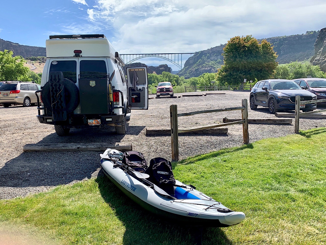
Our destination for the day was Branbury Campground. For a $5 parking fee, they will let you access the river from their boat ramp.

The plan was to paddle downstream about 1-1/2 miles to Blue Heart Springs. Blue Heart Springs is a large pool of very clear water, just off the Snake River. Even though it was downstream, there was a brisk wind blowing upstream, so it was still some work to paddle down the river and it took us 35 minutes to reach our destination. You enter the springs through a narrow path between the trees and brush. The water is crystal clear, with a slight blue tint from the minerals. We were the first ones at the spring this morning, but more kayakers showed up later.


After some time at the springs we started back. This time we had to paddle upstream. However, the winds had died down, so we didn’t have any help on the 50 minute paddle back to the campground.

We drove north on highway 75 to the Stanton Crossing campground. This is a free campground on the banks of the Big Wood River. It was a very nice spot in the trees. The trees were full of birds that singing all night long. There were a lot of other campers, but the sites are spread out, so it didn’t feel too crowded. We cooked and ate dinner while sitting in the shade of the trees. The night was nice, except for the RV that ran their generator all night long.


We had a slow morning as we cleaned up the van and enjoyed at late breakfast at the campsite. Our goal for the day was to drive and camp somewhere near Idaho Falls.

Our morning drive was across the broad Sliver Creek Valley. The valley was lush and green with many large ranches and farms throughout the valley. It was quite pretty and looked like a great place to live.

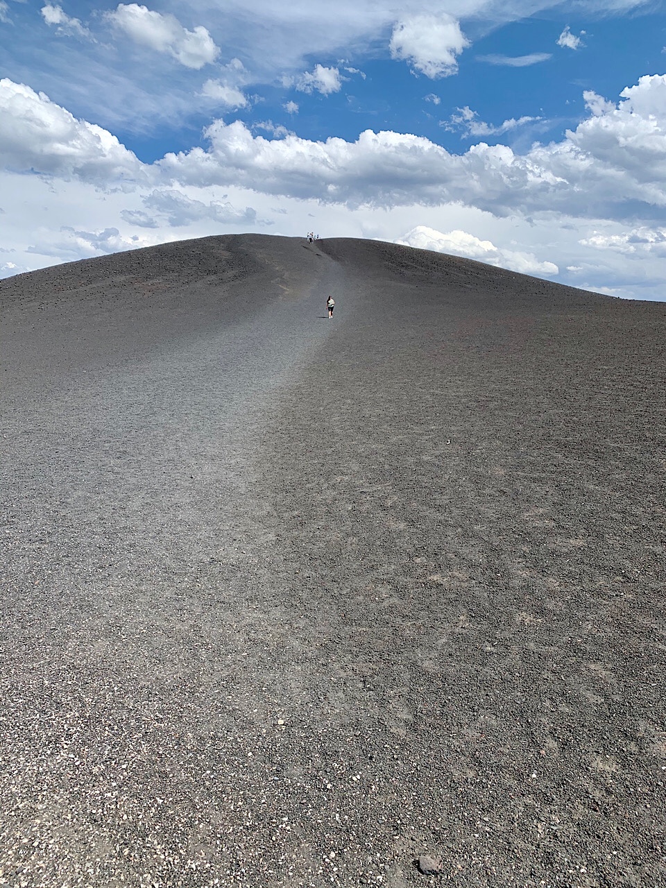
After leaving passing through the town of Carey we entered the high desert. The valleys were full of sage brush, volcanic rock and lava flows. After about 30 miles, we entered Craters of the Moon National Monument. Due to Covid-19, the visitor’s center and the lava caves were closed, but we still took a drive around the scenic loop.

We drove the scenic loop and hiked to the top of the Inferno Cone. From the top you cold see the vast area that is covered by lava flow and cinders. It was very windy on the top. We only saw 3-4 other vehicles on the drive, so it was nice to have some privacy in the park.


We also stopped at the Spattered Cinder Cones. These cones had deep holes that still had snow in them. When you leaned through the fence you could feel the cool air rising from deep in the earth.


After driving through the park we continued on highway 20 towards Arco. This was more high desert and lava. Just as we arrived in Arco, it started raining and for a while it was a hard rain. Arco is known as Idaho’s atomic city and was the first city lighted by atomic energy. Further down the highway is the Idaho National Laboratory. This is where the US government does a lot of their nuclear research.


We stopped for the night at the “Half Acre of Hell” trailhead. This is another large lava flow that has hiking trails through the formations. We found a spot down the side road and set up camp for the night. It was a little windy through the night, but overall a warm pleasant evening.


While we were passing through Idaho Falls the weather went from cool and rainy to flakes of snow and hail falling by the evening. Two days ago it was 93 degrees and sunny and now snow is falling.

We left Idaho Falls and drove east through the rolling hills and followed the Snake River. The valleys are full of farms and ranches with miles and miles of beautiful green fields. About 30 miles east of Idaho Falls we entered Swan Valley. This was a large valley with just a couple of large ranches. The Snake River winds its way through the valley.

We stopped for a while at Fall Creek Falls, a beautiful waterfall from a creek that feeds the Snake River. We had planned to camp in the area, but since it was wet and raining, we decide to drive back to the west. If we were going to be sitting in the van, we might as well be driving.


We drove back to the west through Idaho Falls and Arco. At Arco we turned north on highway 93 and drove north through Mackay. Just past Mackay we camped at a nice campsite on the river. The rain was off and on, so we didn’t spent much time outside. By the time we ate dinner, the snow and hail was falling, so we spent the evening in the van. Through the night I could hear the hail hitting the top of the van, but none of it stayed on the ground.


In the morning it was cold and snowing a bit, but not enough to stick to the ground. We left the campsite and continued north on highway 93. About 8-10 miles north, as elevation rose, there was 3-4 inches of snow on the ground, so it was good we camped down by the river.


The highway north followed the Salmon River through wide green valleys with cattle ranches and alfalfa farms. We arrived at the “town” of Elk Bend and parked at a trailhead about a mile off the highway.

Our destination was Goldbug Hot Springs. It was a challenging hike up the mountain to the hot springs. It was still raining when we arrived, but we waited for 15 minutes and the rain stopped and the sun kind of came out.


The hot springs consisted of 3 separate pools that varied in temperature. The pools were built of rock into the mountain side and the bottom was nice soft gravel. The water was crystal clear and the pool we were in was probably 100 degrees. It felt just the perfect temperature.

We went to the warmest pool, which also had the best view. When we arrived there were only 6 others in our pool and another 6-8 people in the other pools.


However, after about 30 minutes a huge family with lots of kids showed up. There must have been 15-20 of them. They all crowded in our pool, but they were pretty polite and jammed themselves into one side of the pool and left us and another couple the other half of the pool. The kids were climbing around and having fun, so it wasn’t very peaceful.


After about an hour we decided to head back down to the van. It was sunny when we got out and changed, but we were only 10 minutes down the trail when the storm hit. The wind kicked up and the hail started to come down. We were still high on the mountain in the rocks, so there was nowhere to hide. We hurried down towards the trees where we could get some shelter. However, by the time we made it to the trees, the hail had stopped. So we continued down the trail and by the time we made it to the van, the sun was shining and it was a beautiful day again.


From Elk Bend we went back up the canyon and found camp at the Colston River Access. Idaho is full of the river access points that have free campsites on the banks of the big rivers. Our campsite was in a grassy meadow on the banks of the Salmon River, just across from a large cliff. It was another very nice night, however, about 5 minutes after we arrived, the sun went down behind the cliff, and it turned cold. We ate dinner and then played Phase 10 for the rest of the evening.

cthayn is offline   Reply With Quote
Old 11-15-2020, 03:55 PM   #3
Senior Member
 
marret's Avatar
 
Join Date: Nov 2016
Location: FL and VA
Posts: 1,953
Garage
Awesome trip and report. I am making notes for my next trip out west.

How do you like the kayak? Brand and model? How small does it pack down?
__________________
Chris
2008 GMC 3500 Quigley Weldtec 4x4 Savana SMB
marret is offline   Reply With Quote
Old 11-15-2020, 04:00 PM   #4
Senior Member
 
Join Date: May 2017
Posts: 201
Part 3

The next morning we drove 40 minutes up the canyon to Challis, ID. We then headed west on highway 75. This was another beautiful highway following the Salmon River up to Stanley, ID. From Stanley we continued west over the mountains into the Boise National Forest. We found a campsite at the Bonneville Campground for $7.50/night.


The campground was pretty nice with plenty of space between the sites. The best part were some very nice hot springs just 1/4 miles from the campground. These hot springs were on the banks of the Payette River and were very hot.


After setting up camp we hiked over the hot springs. The water flows from several places on the mountainside and is probably > 180 degrees. High on the hill it was too hot to touch. Most of the water flows down a short waterfall down to a series of pools that are spaced through the river bottoms. The upper pools were too hot to get into, but someone told us that the previous day they were a very pleasant temperature.


We found a nice pool where the hot water and cold river water mixed to make a nice spot that was about hot tub temperature.


We were never alone, but it was nowhere near as crowded as yesterday’s hot springs.

After soaking in the pools, we hiked back to camp and Eva made some chicken and pasta for dinner in the Instapot. It was very good. It was a mild night so we cooked and ate outside.

After a morning dip back in the hot springs, we left camp and drove highway 21 to Idaho City. The highway over the mountain has the be the windiest road I have ever been on. There are many hairpin turns that take you up and over the mountain. I would hate to pull a big trailer on this road.

We stopped for lunch at the visitor’s center in Idaho City. We were still about an hour drive from Boise, but since the camping prospects were very good near Boise, we decided to continue down the canyon about 10 miles to a nice dispersed camping spot a few miles off the road. We set up camp and also took showers. The rest of the evening we hung around camp and did a short hike. It was the first warm evening for about a week, so we stayed outside until dark.


After leaving camp the next morning we drove down the mountains into Boise. Our first stop was the Old Idaho State Prison. It is now a museum, but due to Covid, it was closed. We went there to hike on some of the Boise trails. We did a short, but steep hike to a cliff area that gives an overlook of Boise.

We then continued to downtown Boise, stopping at Freak Alley. An alley with lots of pictures painted on the walls.


About 15 miles south of Boise is the Kuna Cave. It is a large lava tube that his 1000’ long. The beginning is just a 15’ diameter hole in the flat desert. You have to climb down a 50’ steel ladder, but once at the bottom the cavern has a flat floor, so it is pretty easy to explore. The walls of the cavern are covered with layers of graffiti, probably from many years of kids painting on the walls.


Once we finished at the cave, we were officially on our way home. We headed east on I84, back through Twin Falls and then camped our last night at McClendon Springs, the same site as our first night. It was just the right distance from home.


Trip Stats

10 nights
1550 miles
cthayn is offline   Reply With Quote
Old 11-15-2020, 04:08 PM   #5
Senior Member
 
Join Date: May 2017
Posts: 201
Quote:
Originally Posted by marret View Post
How do you like the kayak? Brand and model? How small does it pack down?
The kayak is a Sea Eagle 385FT. It is awesome. We bought it used, it was about 6-7 years old. I expect to get 15+ more years out of it. They are built tough and perform well. Not as fast as a hard shell sea kayak, but closer to that than the standard inflatable kayaks.

It packs down to a 3'x2'x1' cube. We strap it on top of our bumper mount Aluminess box. We carried the kayak back there for 3000 miles through Baja.

>> Corey
cthayn is offline   Reply With Quote
Old 11-15-2020, 04:41 PM   #6
Senior Member
 
marret's Avatar
 
Join Date: Nov 2016
Location: FL and VA
Posts: 1,953
Garage
Quote:
Originally Posted by cthayn View Post
The kayak is a Sea Eagle 385FT. It is awesome. We bought it used, it was about 6-7 years old. I expect to get 15+ more years out of it. They are built tough and perform well. Not as fast as a hard shell sea kayak, but closer to that than the standard inflatable kayaks.

It packs down to a 3'x2'x1' cube. We strap it on top of our bumper mount Aluminess box. We carried the kayak back there for 3000 miles through Baja.

>> Corey
Thanks. I plan to buy an inflatable at some point.
__________________
Chris
2008 GMC 3500 Quigley Weldtec 4x4 Savana SMB
marret is offline   Reply With Quote
Old 11-15-2020, 04:52 PM   #7
Site Team
 
BroncoHauler's Avatar
 
Join Date: May 2007
Location: Southern New Mexico
Posts: 10,179
Wow, Blue Heart Springs looks amazing and inviting.


Herb
__________________
SMB-less as of 02/04/2012. Our savings account is richer, but our adventures are poorer.
BroncoHauler is offline   Reply With Quote
Old 11-15-2020, 05:35 PM   #8
Senior Member
 
Twoxentrix's Avatar
 
Join Date: Mar 2015
Location: Maryland
Posts: 3,381
Garage
Drooling with envy here as I scroll through your trip report cthayn - some very cool places!

Very happy Marret inquired about the Kayak, we had been talking about one as well, but had no idea they collapse to such a manageable size.
__________________
TwoXentrix
"AWOL"
Twoxentrix is offline   Reply With Quote
Old 11-15-2020, 05:53 PM   #9
Senior Member
 
Join Date: May 2017
Posts: 201
We love our inflatable kayak. Last year we did 3 days on the Green River through Labyrinth Canyon, along with several other rivers and lakes. We also used it several places on the Sea of Cortez during our Baja trip earlier this year.

Here is a link to an article I wrote for the Sea Eagle blog documenting our Labyrinth Canyon trip.

https://blog.seaeagle.com/2019/09/03...sttrack-385ft/
cthayn is offline   Reply With Quote
Old 11-15-2020, 06:59 PM   #10
Senior Member
 
Steve C's Avatar
 
Join Date: Apr 2018
Location: West Central Mountains, Idaho
Posts: 479
Garage
Looks like you had a great trip and did a really good report on it. I need to venture a little further south next Spring and check out some of the kayaking near Twin Falls.
__________________
2001 Sportsmobile RB50 7.3
West Central Mountains, Idaho
Steve C is offline   Reply With Quote
Reply


Posting Rules
You may not post new threads
You may not post replies
You may not post attachments
You may not edit your posts

BB code is On
Smilies are On
[IMG] code is On
HTML code is Off
Trackbacks are Off
Pingbacks are Off
Refbacks are Off

» Featured Campgrounds

Reviews provided by

Powered by vBadvanced CMPS v3.2.3
Disclaimer:

This website is not affiliated with or endorsed by Sportsmobile SIP or any of its affiliates. This is an independent, unofficial site.


All times are GMT -6. The time now is 11:28 AM.


Powered by vBulletin® Version 3.8.8 Beta 4
Copyright ©2000 - 2024, vBulletin Solutions, Inc.