|
|
 07-09-2013, 02:50 PM
|
#31
|
|
Member
Join Date: Jan 2013
Posts: 73
|
Re: Nissan SMB
We were issued mini batons with a spray cartridge in it. Most of us did not want the spray due to blow back, but it made a great key chain. The trainers took a soaked, cotton swab, dabbed it in the corner of our eyes and along the lower lid. Instant pain, then looking for the water hose to rinse out our eyes. What I liked most was when the trainer demonstrated how to use the mini baton spray, it was empty. This was important later on when I was driving my state car; the whole thing fell apart, the safety lock included. The canister was empty. Never requested a refill.
Installment 14 (5/29/13)
We retraced our route on 9 and 1 back to Anchorage, stopping briefly at the inland glacier in Kenai National Park. We decided not to hike in to the "toe" of the glacier; there also is a hike on trails along, but not on the glacier. Instead of going to Wasilla, we continued on route 1 through Palmer to get to the Matanuska Glacier.
We stayed at "State Reserve," primative campground very near the entrance to the Glacier Park. East of the day use area, is a great trail with views of the glacier.
There a 2 companies that offer guided treks on the glacier. (You can also just pay an entrance fee, but you don't get crampons, and there are no marked trails.) Mica is the one we knew about, but they required reservations, and we would have to wait until 1630. The other was Matanuska Glacier Adventures. When I called them around 0800, I was asked if they could call me back. We waited awhile, then drove down the hill. The problem was only one guide was in the office, and he was trying to find out when bridge repairs (glacier melt) would be completed. He told us to drive up to the glacier and he would meet us within an hour. It was less than that. We were the only ones in the group and he suggested we bring our dogs. (The only issue would be tender paws, but this was not a problem.) This was one incredible trek.
|

|

|
|
07-09-2013, 02:56 PM
|
#32
|
|
Member
Join Date: Jan 2013
Posts: 73
|
Re: Nissan SMB
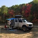
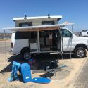
Installment 14 continued:
No words needed.
|
|
|
|
|
07-09-2013, 02:59 PM
|
#33
|
|
Member
Join Date: Jan 2013
Posts: 73
|
Re: Nissan SMB
Installment 14 continued again:
|
|
|
|
|
07-09-2013, 03:22 PM
|
#34
|
|
Member
Join Date: Jan 2013
Posts: 73
|
Re: Nissan SMB
Installment 14 continued one more time:
One thing you will miss without a guide are ice caves. We were the last to see this one, as they quickly collapse. Another issue is safety, as the glacier changes day to day. In one instance, we had to use ice axes. Crampons and ice axes are usually not something I keep in the glove box.
While there, we found out they have campsites. These are very primitive. We chose to drive out and stay at the Glacier View RV Park. They have hookups, showers, laundry as well as a restaurant. We decided "to go out on the town" at their restaurant and have pizza. Great!
|
|
|
|
|
07-10-2013, 02:15 PM
|
#35
|
|
Member
Join Date: Jan 2013
Posts: 73
|
Re: Nissan SMB
Installment 15 (5/31-6/1/13)
Headed toward Glennallen on route 1/junction with route 4. We intended to turn right toward Valdez and turn onto route 10 to McCarthy/Kennicott. (A cycling friend's family homesteaded there and said the area was beautiful.) Enroute to Glennallen, we learned there was flooding, and we couldn't get past the Copper River at Chitina. So we turned left onto route 4 until route 1 branched off to Tok. Enroute, we encountered flooding, some coming onto the road as we neared Tok. At the visitor center, we checked to see if "Top of the World" was open and if the ferry to Dawson (City) was operating. Yes to both.
The first half of route 5 is paved to Chicken (population of 3 in the winter and 27 in the summer). We stayed at the RV park there, because we had already driven over 300 miles and the road to Dawson is dirt. This is gold mining country, and you can pan for gold. Even though there was a river nearby and a stream running by the campground, all the water was trucked in. You can camp for free up the hill near the bar.
Route 5, now dirt, continues to Eagle, a mining supply town with a population of 86. At the junction, we took route 9, dirt and worse, to Dawson. Since the border stations are only open from 0800/0900 to 2200/2300 depending on Yukon or Alaska time, we had no on-coming traffic for the very narrow places with blind corners. (We later encountered huge RVs, semis and Touring Busses.) The actual border crossing is above the tree line. There was no snow, but some of the sheltered drifts were taller than the NV. The road had been chip sealed at some point, but it basically was loose gravel.
When we got to the Yukon River ferry crossing, the river was running high and fast. The Mile Post warns that you may wait up to 3 hours to cross, as they load vehicles according to size. There was a wait on the other side, but only a pickup crossed with us to Dawson.
There are 2 visitor centers in Dawson; one for Dawson and the other for the Northwest Territories. Both informed us the Demspter Highway was closed due to a washout at the Ogilvie River. It might be repaired by mid-week (6/5). So, we headed to the only bakery for coffee, scones and a loaf of bread. The owner told us he had never seen the river from his store over the dike. He said the flooding was due to getting 25'+ feet of snow in the mountains, when they normally get 10'.
We planned to stay at one of 2 provincial campgrounds, but both were under water. We continued on to the Dempster Highway to the campground at Tombstone Territorial Park.
|
|
|
|
|
07-11-2013, 05:56 PM
|
#36
|
|
Member
Join Date: Jan 2013
Posts: 73
|
Re: Nissan SMB
Installment 16 (6/2/13)
The Dempster Highway is gravel from start to finish (456 miles to Inuvik); you go as far as you want, then make a u-turn. The road was dry and dusty, with no signs of flooding. We only drove to the Tombstone Range and alpine tundra viewpoint, 46 miles in. We stayed at the campground at mile post 44. The next morning, we checked with the wardens at the visitor center (well worth seeing). 30k of road was washed out at the Olgivie River, milepost 121, and the road was restricted to one lane due to flooding on the road before that. No opening was projected, so we headed back to route 2 and Whitehorse.
Aside from the flooding due to snow melt, it was great to see trees leafed out, flowers and wildlife. I doubt we will ever return this way, even though one of our goals was to get to the Arctic Circle. We stayed at an RV park in Carmacks. The camp host was the bartender in the lounge of the historic Hotel Carmacks. Our site was behind the lounge; we expected the worst, but it was very quiet.
|
|
|
|
|
07-13-2013, 04:16 PM
|
#37
|
|
Member
Join Date: Jan 2013
Posts: 73
|
Re: Nissan SMB
Installment 17 (6/3-5/13)
We continued on route 2 to Whitehorse and the junction with route 1. We used the RV wash at Caribou RV Park and drove to Teslin to see the Inland Tlingit Heritage Center. When we earlier drove by, it wasn't open. This is worth stopping and taking the time to see their movie. Although too long and in need of editing, the dancing, singing and drumming were for their community not for tourists. We camped at Teslin Lake Provincial Campground, about 7 miles north of the center.
The next morning, I forgot to check the gas gauge and map. It was a tense drive to the Continental Divide Restaurant, gas station, bar and RV park. $129 later, the tank was full. We decided to have breakfast ($30), but it worth it to sit down and talk with other travelers and locals. These roadhouses are not just for travelers.
Not very far south, route 1 had been washed out by flooding. Road crews were just finishing, but we were unable to go to Rancheria Falls. It was only a short distance to the junction of route 37, the Cassiar Highway. The northern half is narrow with no shoulder or center lines. Most of the logging and zinc mining trucks were headed south to Stewart, so we just got out of their way whenever possible. A bigger problem were the many rental RVs headed north. We got gas in Dease Lake and stayed at a RV park there.
Several people recommended Stewart, BC, so we detoured on to route 37A, a downhill drive through a fjord, with glaciers to the south and avalanches to the north, to Steward on the Portland Canal. Hyder, AK is there as well. There is a 23 mile self guided auto tour to the Salmon Glacier overlook. You can continue beyond this on non-maintained roads.
There is a municipal park in Stewart, but it apparently was closed. The place to stay is Bear River RV Park. We chose "dry camping" and camped on the grass. It was cool and raining so we passed on the car tour.
|
|
|
|
|
07-14-2013, 04:07 PM
|
#38
|
|
Member
Join Date: Jan 2013
Posts: 73
|
Alaska in a Nissan SMB
Installment 18 (6/6/13)
Left Stewart after stopping at Temptations for strawberry muffins, coffee and a loaf of bread. Bi-passed the only gas station in Stewart to get gas at the junction of routes 37A and 37. There was a gas pump, but not for the public, so we continued on route 37 looking for a roadhouse that had a gas pump. It looked like we would have enough gas to get us to the junction with route 16.
At the turn off to Gitanyow before route 16, there was a sign for the town and "Gas/Bar." This is an historic town with very old totems. Filled the tank amongst the totems; after which, we walked around in the rain. In addition to the old totems, a totem was being carved. We learned from the grandson of the chief the totem honored that they were finishing the totem. When first erected, the family/clan did not have the funds to complete it. A master carver and hereditary chief from another clan (per custom), was carving a killer whale. He showed us a slip of paper based on 1' squares that he was using to transfer and carve the design. He had been carving over 40 years; his grandfather, a famous chief also was a master carver. "Paint isn't needed" on these totems, due to the depth of the relief. The totem may be erected this summer, according to the Grandson; there is no date for completion. We would like to go back.
We watched for awhile and walked around the totems before returning to route 37. If you have time, take the short detour at Kitwanga to see Battle Hill.
|
|
|
|
|
07-14-2013, 04:33 PM
|
#39
|
|
Member
Join Date: Jan 2013
Posts: 73
|
Re: Nissan SMB
Installment 19 (6/6-7/13)
Turned right on route 16 toward Prince Rupert. Not sure why we decided to go there, but it turned out we found Dolly's Fish Market, the best fish place, ever.
There is a campground, near the ferry terminal, in the southern part of town.
We decided, instead to go look for a place to eat. We drove back through town and ended up in Cow Bay, a tourist area with a Holstein motif. Just before the cow motif ends, turn right and look for a large whale mural and parking lot. Dolly's is across the street. You will know you are in the right place when you read: "Take your fish to be processed to the side door." The menu is on a large blackboard. Too many choices. We will go back just for Dolly"s.
After eating we still had to find a place to stay. There is a RV park in Port Edward, and we stayed there. Tight spaces and very wet.
Port Edward has a historic cannery you can tour, but no town center. It primarily is a residential area for a population of 500.
|
|
|
|
|
07-15-2013, 11:56 AM
|
#40
|
|
Member
Join Date: Jan 2013
Posts: 73
|
Re: Nissan SMB
Installment 20 (6/8-9/13)
Headed east on route 16 to "Old" Hazelton, as opposed to New and South Hazelton, to see K'san, a Historical Gitxsan Village and Museum. We stayed at their campground (full hookups, tent sites and a shower/laundry). Wifi was available, but you had to try and find it.
The museum is well worth seeing. You can walk around the traditional longhouses and take photos. Taking the tour and entering 3 of the long houses is worth the $9 admission. You, however, cannot take pictures of the interiors and their stunning contents.
The historic town has galleries and places to eat.
From this point on, the roads improved, the vegetation was green, there was no visible snow on the mountains and gas was cheaper. It continued to rain, but stopped whenever we did.
|
|
|
|
|
|
 Posting Rules
|
You may not post new threads
You may not post replies
You may not post attachments
You may not edit your posts
HTML code is Off
|
|
|
|
 » Recent Threads
 |
|
|
|
|
|
|
|
|
|
|
|
|
|
|
|
|
|
|
|
|
|
|
|
|
|
|
|
|
|
|
|
|
|


 Linear Mode