|
|
 02-21-2024, 09:25 AM
|
#11
|
|
Senior Member
Join Date: Mar 2013
Posts: 4,244
|
Quote:
Originally Posted by jeff00seattle

|
I run GAIA on an iPad mounted on the dog house. My particular IPad doesnt have a built in GPS, so I also have a Bluetooth GPS. Unlike Scotty, Ive found it to be reasonably easy to use, but it is feature rich, so there is a bit of a learning curve. It does not require a cell signal, but you have to pre load maps if you dont have internet. When you do have service, it automatically loads maps of the area your in. There is a large number of different map types too, I use Backroad maps in Canada, theres also ones that show gold mines, ghost towns, fire activity, BLM lands and tons more.
__________________
Arctic Traveller
KC6TNI
2001 GTRV
Advanced 4wd
Agile Ride improvement package
|

|

|
|
02-21-2024, 09:28 AM
|
#12
|
|
Senior Member
Join Date: Jul 2023
Location: Harrington, WA
Posts: 281
|
I've never had a phone that had a great compass. The GPS works decent enough with exposure to enough satellites, and track can be plotted if your using a map on your device, but for getting bearings and 'dead reckoning' I really like a good old fashioned whiskey compass, or the dry version if it needs to be portable.
Decent fixed compasses have calibration screws to compensate for the metal surrounding structure and interference from electrical devices. Just make sure to take into consideration what you want to have on when you calibrate, and whats not on when you use it.
As a side bonus, a compass never needs charging.
For more detailed off-network stuff I use Avenza on a smart device. It still drops the gps signal in big mountains and deep forest, but I use it to record my track and find my way home if I get lost. I download area contour maps ahead of time so I don't need any kind of signal. I usually use USFS MVUM to see if the roads I'm on are open or not. I often have another base map loaded, as the MVUM are not as detailed as I like and don't show many foot trails.
|
|
|
|
|
02-22-2024, 04:45 PM
|
#13
|
|
Junior Member
Join Date: Feb 2024
Posts: 12
|
Quote:
Originally Posted by arctictraveller
I run GAIA on an iPad mounted on the dog house. My particular IPad doesnt have a built in GPS, so I also have a Bluetooth GPS. Unlike Scotty, Ive found it to be reasonably easy to use, but it is feature rich, so there is a bit of a learning curve. It does not require a cell signal, but you have to pre load maps if you dont have internet. When you do have service, it automatically loads maps of the area your in. There is a large number of different map types too, I use Backroad maps in Canada, theres also ones that show gold mines, ghost towns, fire activity, BLM lands and tons more.
|
I also use an Ipad on my dash with a Garmin GLO bluetooth GPS. I use Gaia and have downloaded maps for all of the continental US (because that is my focus - I'm sure you can download worldwide maps). I seldom use automated navigation systems (like google maps) so I just read the digital map as if I was reading an old fashioned paper map.
|
|
|
|
|
02-25-2024, 11:15 AM
|
#14
|
|
Senior Member
Join Date: Nov 2015
Location: Massachusetts
Posts: 113
|
Quote:
Originally Posted by arctictraveller
I run GAIA on an iPad mounted on the dog house. My particular IPad doesnt have a built in GPS, so I also have a Bluetooth GPS. Unlike Scotty, Ive found it to be reasonably easy to use, but it is feature rich, so there is a bit of a learning curve. It does not require a cell signal, but you have to pre load maps if you dont have internet. When you do have service, it automatically loads maps of the area your in. There is a large number of different map types too, I use Backroad maps in Canada, theres also ones that show gold mines, ghost towns, fire activity, BLM lands and tons more.
|
Yeah, I do the same in my Sprinter; iPad mini mounted on a 10" ProClip mounting arm coming off the center console below the radio.
GaiaGPS's biggest item is its breadth of map overlays that they have available. I just wish they'd spend some of the money from the increased subscription prices on squashing some of the bugs. I've tried other mapping software, but I keep coming back to GaiaGPS for the map overlays.
Anytime I'm taking the van out for more than a local errand run, I've got the tracking running on Gaia. It's fun pulling up national map with all my recorded tracks displayed to see where we've been. I also have tons of recorded waypoints for campsites, fuel stops, water points, as well as waypoints for places I want to visit that I saw in an article or on YouTube channel.
|
|
|
|
|
02-26-2024, 09:10 AM
|
#15
|
|
Member
Join Date: Sep 2022
Location: NJ
Posts: 87
|
For day to day driving, where I mostly know where I'm going, I prefer Waze. But I also heavily rely on a Garmin RV unit to help out. The Garmin RV units allow you to set a vehicle profile with dimensions and your weight, plus propane tank size. It then diverts you around places you can't travel, particularly bridges and tunnels. For instance, there are a few bridges around me that bypass the toll bridge, but they are 2 lanes, about 18ft wide, and have a 3 ton GVWR maximum. Waze always says to go over them, because it doesn't know that the fine far exceeds the $1.25 toll of the 5 lane bridge with a 40 Ton limit.
My issue with Gaia is that every single person using it lays a track down, whether you should be following it or not. It's heavily used by SXS, Dirtbikes, and ATVs which makes certain roads/trails look accessible, when they're not. I like it as an ancillary mapping service but find that Google maps is more than good enough. If a road isn't on google maps, then there better be a very good reason that I need to go down it.
|
|
|
|
|
02-26-2024, 09:58 AM
|
#16
|
|
Senior Member
Join Date: Feb 2010
Location: Burbank
Posts: 287
|
OK I am now very confused.
Here is my Delima: I travel primarily in the western US. I go of road occasionally to reach a fishing location. I use my iPhone (13) but once I hit the dirt it often shows a green screen with a white line indicating the road I am on. No details: topography, landmarks, not even the destination when I get there.
I have read a great deal about those who use an iPad.
I want to see the details of the road and surrounding areas I am traveling through.
NV, UT, WY & CO are the most frequented states.
I am open to suggestions and recommendations. Cost is not the issue if it gives the best visual maps and detailed info. I seek.
I'm tired of the green screen and white line. I am prepping for my 2024 ventures and want to have a suitable GPS system.
HIGHCOUNTRYMIKE 2003 E350 SPORTSMOBILE 4X4, 7.3, 320,000
|
|
|
|
|
02-26-2024, 10:41 AM
|
#17
|
|
Junior Member
Join Date: Feb 2024
Posts: 12
|
Quote:
Originally Posted by HIGHCOUNTRYMIKE
OK I am now very confused.
Here is my Delima: I travel primarily in the western US. I go of road occasionally to reach a fishing location. I use my iPhone (13) but once I hit the dirt it often shows a green screen with a white line indicating the road I am on. No details: topography, landmarks, not even the destination when I get there.
I have read a great deal about those who use an iPad.
I want to see the details of the road and surrounding areas I am traveling through.
NV, UT, WY & CO are the most frequented states.
I am open to suggestions and recommendations. Cost is not the issue if it gives the best visual maps and detailed info. I seek.
I'm tired of the green screen and white line. I am prepping for my 2024 ventures and want to have a suitable GPS system.
HIGHCOUNTRYMIKE 2003 E350 SPORTSMOBILE 4X4, 7.3, 320,000
|
Heres a shot from Gaia. It is a topi map once you zoom to a certain level but as you zoom out you do start to lose the details. I assume but cant confirm that OnX backcountry (or whatever its called) is also topographic.
I download the maps to my iPad - which has only Wi-Fi, no cellular nor GPS - then I connect it Bluetooth to the Garmon Glo device. I mount it to my dash using a ProClip mount.
I am frequently out west and this is a shot from within the Medicine Bow NF near the Snowy Mountains.
|
|
|
|
|
02-26-2024, 11:53 AM
|
#18
|
|
Senior Member
Join Date: Jan 2012
Location: Middle of Nevada
Posts: 304
|
Quote:
Originally Posted by jeff00seattle
Thank you
Which GPS unit of the image you have posted?
|
That is an ancient Garmin Montana 600...don't remember but it has to be at least 10 years old. But it still works fine. I still use it...I'm part of a Search and Rescue group and in certain cases it is handy to have more than one GPS unit running, each showing different information. Most of the time I use my new Garmin Montana 750i because it has the InReach circuitry built in so I can send/receive text messages via satellite no matter where I am. No cell signal needed. Being much newer, the Garmin 700 series is a lot more capable - so many features that I'll never use but I still like it very much. It too can display any number of pieces of information a person may find handy.
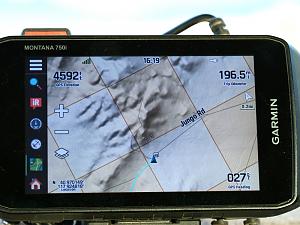
You'll notice that I've got, clockwise from the upper left, elevation, current time, trip mileage, direction of travel, and exact GPS coordinates of my location showing on the screen at all times. One of the map layers that comes with the Montana 700 is land status; in this picture the beige colored squares are public land, the white squares are private land. You can get a powered cradle for either the Montana 600 or 700 series so it can run off your vehicle's 12 volts and battery life is not a consideration. But be forewarned...Garmin is very proud of these units; they are expensive. For me they are worth it because I use them all the time.
__________________
Worshipper of Wild Country
2007 Quigley V-10 on 33s with 4.56 gears (Toyhauler)
|
|
|
|
|
02-26-2024, 12:01 PM
|
#19
|
|
Senior Member
Join Date: Sep 2018
Posts: 624
|
I had a dashboard compass in my Mercedes 300TD for a while. I found it was pretty useless for navigation, but it worked very well as a galvanometer to tell me when the glow plugs were on. 
__________________
N8SRE
1990 E-250 Sportsmobile w/ penthouse top, converted when new by SMB Texas.
|
|
|
|
|
02-26-2024, 12:05 PM
|
#20
|
|
Senior Member
Join Date: Sep 2018
Posts: 624
|
Quote:
Originally Posted by BlackSheep
Here’s a shot from Gaia. It is a topi map once you zoom to a certain level but as you zoom out you do start to lose the details. I assume but can’t confirm that OnX backcountry (or whatever it’s called) is also topographic.
|
Probably worth noting that if you're a subscriber to Outside magazine you get Gaia for free. I agree with people who say it's somewhat user-unfriendly, but once you get used to it it's pretty good for off-highway navigation. As with Google Maps you need to remember to download offline maps before hand if you won't have Internet service.
For basic direction, altitude, and speed info there's an iOS app called "Speedometer 55" that works pretty well. Might be good if you find a moving map distracting, or if you specifically need a trip odometer. (My van doesn't have one.)
One thing to watch out for is all of these apps will use your phone's built in magnetic compass when they're stopped, and switch to GPS track direction when you're moving. (Sometimes this is configurable.) The magnetic compass will be vulnerable to all the same error modes as a dash compass, so direction when stopped is not always reliable.
__________________
N8SRE
1990 E-250 Sportsmobile w/ penthouse top, converted when new by SMB Texas.
|
|
|
|
|
|
 Posting Rules
|
You may not post new threads
You may not post replies
You may not post attachments
You may not edit your posts
HTML code is Off
|
|
|
|
 » Recent Threads
 |
|
|
|
|
|
|
|
|
|
|
|
|
|
|
|
|
|
|
|
|
|
|
|
|
|
|
|
|
|
|
|
|
|


 (No name yet)
 CSC TT250 + homebuilt trailer
 Linear Mode