Quote:
Originally Posted by HIGHCOUNTRYMIKE

OK I am now very confused.
Here is my Delima: I travel primarily in the western US. I go of road occasionally to reach a fishing location. I use my iPhone (13) but once I hit the dirt it often shows a green screen with a white line indicating the road I am on. No details: topography, landmarks, not even the destination when I get there.
I have read a great deal about those who use an iPad.
I want to see the details of the road and surrounding areas I am traveling through.
NV, UT, WY & CO are the most frequented states.
I am open to suggestions and recommendations. Cost is not the issue if it gives the best visual maps and detailed info. I seek.
I'm tired of the green screen and white line. I am prepping for my 2024 ventures and want to have a suitable GPS system.
HIGHCOUNTRYMIKE 2003 E350 SPORTSMOBILE 4X4, 7.3, 320,000
|
Unless you download an app AND the maps for the area you are traveling in you will not see any details!
A "suitable" GPS system depends on the user. We all have different ideas of the information we want from GPS. If you want detailed information then do as others have recommended and download one of the GPS apps and maps for your phone. I prefer the Garmin Montana GPS units because they are so dependable, can run off 12 volts so no battery worries, and have any number of mapsets you can use. Plus they allow you to create "tracks" to follow as the map scrolls as you drive.
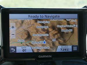
If you want a cheap solution, buy a used Garmin automotive unit and either buy one of the Garmin Topo maps or download a mapset from any number of providers. These offer free maps: gpsfiledepot.com. Most GPS units have a micro-SD slot. Either stick the mapset you bought from Garmin on the microSD in that slot, or load someone else's mapset on your own microSD card and install in that slot and then choose the topo map from the menu on the GPS unit. Here is a shot of my old Garmin RV760 GPS unit, loaded with Garmin's 100k Topo which has the whole United States on the microSD card. All kinds of information to see about the location you are in:
Garmin has a new series of GPS units if price is no object. I've not used one yet but the reviews are pretty darn good. These are the ultimate in GPS and will do just about anything you might want a GPS unit to do. 5, 8 or 10" screen size!
https://www.garmin.com/en-US/p/862533/pn/010-02406-01


 Linear Mode