|
|
 11-13-2023, 04:40 PM
|
#21
|
|
Senior Member
Join Date: Feb 2010
Location: Burbank
Posts: 287
|
Talk about "confused".
I have read so many comments on the various "off road" Garmin's my head is spinning.
So many people had issues with onloading, connecting etc etc I'm kind of turned off by traditional GPS systems.
I travel NV, UT, CO and WY and want to have maps of my off roading trips. I want detailed, informative names, places, streams lakes etc
I don't know what to do. I'm old and need it simple, pulg-in and work.
|

|

|
|
11-13-2023, 06:08 PM
|
#22
|
|
Senior Member
Join Date: Nov 2016
Location: FL and VA
Posts: 1,955
|
As far as I know, there isn't a plug and play option that doesn't involve downloading maps, apps, etc. unless you get a dedicated GPS and deal with the issues.
OsmAnd can have more than roads if you download the appropriate map overlays. These show up as options when you go to download state maps: Standard map, roads-only map, contour lines, terrain, etc.
I also use a Delorme Atlas and Gazetteer for each state. It will give good info.
__________________
Chris
2008 GMC 3500 Quigley Weldtec 4x4 Savana SMB
|
|
|
|
|
11-14-2023, 12:08 PM
|
#23
|
|
Senior Member
Join Date: Jan 2012
Location: Middle of Nevada
Posts: 304
|
Quote:
Originally Posted by HIGHCOUNTRYMIKE

Talk about "confused".
I have read so many comments on the various "off road" Garmin's my head is spinning.
So many people had issues with onloading, connecting etc etc I'm kind of turned off by traditional GPS systems.
I travel NV, UT, CO and WY and want to have maps of my off roading trips. I want detailed, informative names, places, streams lakes etc
I don't know what to do. I'm old and need it simple, pulg-in and work.
|
Unfortunately there's nothing out there that will do all you want, in just one unit.
I tried some of the apps that can be used on Android devices and found them buggy and lacking...reading on the ADV Rider forums just this morning about others having problems with the Gaia app so it's an ongoing thing. So I'm back to using mostly Garmin.
But no one Garmin unit will do what you (and I) want either. So I run a couple Garmin units. One is a Garmin Montana because I need a unit I can load tracks and waypoints onto, to follow out in the back country. But Garmin in their infinite wisdom has disabled the information like names for mountain peaks, lakes, etc. on their "handheld" GPS units like the Montana so even though the information is there on the map, you cannot see it on the screen. I discovered some time ago that some of the Automotive and RV type Garmin GPS units do show all those names...what you see depends on the zoom level you have the GPS set at. Hence the reason for running two GPS units at a time.
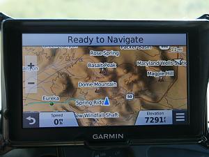
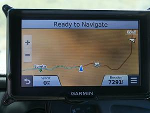
Here's an example, showing both my Montana 600 and my RV760 GPS units in my rig. Both GPS units are using the Garmin 100k maps. Note that the Montana shows only roads/trails/elevation lines on the screen. The RV760 shows names for all the surrounding features, handy so you can compare to a paper map and orient yourself.
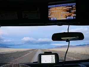
Note that in addition to the cost of the GPS units you'll also have to buy topo maps. The newer Garmin Montana 700 series comes with "Topoactive" maps but they don't have a lot of the more primitive roads on them so if you travel off the beaten path you'll need to buy the Garmin 24k mapsets you are interested in. Garmin automotive/RV GPS units come only with City Navigator maps on them and they show only major roads. (The GPS units all have a micro-SD slot so you can load your choice of additional maps on them).
My RV760 with the Garmin 100k map data:
From the exact same location, switching over to the City Navigator maps:
I cannot speak to the new Garmin "Tread" series of GPS units so no idea if they can show all the information you and I want. But be prepared for sticker shock if you go with any of the Garmin units! As far as connectivity and uploading/downloading information with the Garmin units, I've had no problems at all in the years I've been using Garmin. You will have to download Garmin's "Basecamp" program (free) and learn how to use it.
__________________
Worshipper of Wild Country
2007 Quigley V-10 on 33s with 4.56 gears (Toyhauler)
|
|
|
|
|
11-14-2023, 03:26 PM
|
#24
|
|
Senior Member
Join Date: Mar 2020
Location: North Florida
Posts: 282
|
Quote:
Originally Posted by deserteagle56
But be prepared for sticker shock if you go with any of the Garmin units! As far as connectivity and uploading/downloading information with the Garmin units, I've had no problems at all in the years I've been using Garmin. .
|
I'd prefer a dedicated GPS too but have gotten soured on Garmin over the years. I had 2 or 3 units in the Street Pilot line and really liked the last one I had (2390 I think it was ?) I bought the Lifetime Map updates and it was easy enough to update...until the day it wouldn't update at all. I called them and their answer was "we don't support that unit any longer"..."do you realize it's 4-5 years old"...what i realize more is that you sold me lifetime maps and now won't give me access to updates. After a bit of wrestling they agreed to update me one more time BUT THAT'S IT sir. I don't know what made me more angry, lifetime maps that are really only 4ish years, that they say we don't support it any longer or that that was a lie and they still could update it but choose to cut me off. At any rate they updated it one more time and that was in fact "it", no more updates for you sucker...didn't matter I guess a year or so later the screen went haywire and that was that.
I bought a Montana 650 and though not very intuitive eventually i got the hang of it and liked it. The built in camera was total crap though, then it lost the ability to charge the Nicad battery but I mostly used it on my dirt bike so i used the hardwired rugged cradle, then the case failed at the on/off button so the internals were exposed and i had to turn it on/off with a paper clip and could only use it in the van now...the touch screen started going wonky a few months back. I have since learned you can buy reconditioned units from Garmin which amazingly enough a guy at Garmin told me that when someone sends a unit in for warranty that they send him a new unit and then change the screen on what he sent back and then sell his as a reconditioned unit. The recon units save you quite a bit, may want to check if they offer the model you want before buying full price, it's not like either is going to last very long anyway. He claimed screen failure is almost always the reason for warranty returns.
Seems like dedicated GPSs prices would have come down with all the iphone based apps out there now but I guess not, for some reason.
Most recently, while waiting for the Montana to completely give up the ghost, I've been using OnX-Offroad app on my iphone12, it's ok I guess, some nice features but the huge drawback I've experienced is it eats your battery at a ridiculous rate. If you're lost with no way to charge...you're a dead man. They also have OnX Backcountry, OnX Hunt, OnX MTB, On X this and that.
__________________
Steve
2008 E350 V10 EB Cargo "CAZA-mobile"
2014 Triumph 675 Daytona track bike
2019 Yeti SB130 Turq Race X01
|
|
|
|
|
11-14-2023, 03:54 PM
|
#25
|
|
Senior Member
Join Date: Sep 2020
Posts: 379
|
Quote:
Originally Posted by Steve Hunt
I'd prefer a dedicated GPS too but have gotten soured on Garmin over the years.
|
Me too. I have one of their RV units and some of the things it does badly are just mind boggling. It's technology where the more you use it, the more you dislike it.
Clearly designed by engineers sitting in their cubicles playing with computers, not by people who actually use the thing. After 30+ years working in tech, I can say that is the norm, unfortunately.
Textbook case of a company that could use some stiff competition.
|
|
|
|
|
11-14-2023, 05:54 PM
|
#26
|
|
Senior Member
Join Date: Mar 2020
Location: North Florida
Posts: 282
|
Quote:
Originally Posted by N147JK
Textbook case of a company that could use some stiff competition.
|
I agree and was sure hoping that all the apps popping up would be that competition that would straighten out Garmin tech and their prices but I'm still waiting. 
__________________
Steve
2008 E350 V10 EB Cargo "CAZA-mobile"
2014 Triumph 675 Daytona track bike
2019 Yeti SB130 Turq Race X01
|
|
|
|
|
11-14-2023, 07:10 PM
|
#27
|
|
Senior Member
Join Date: Mar 2023
Posts: 147
|
I have been extremely happy with OnX Offroad with downloaded maps, displayed on my 10" in-dash screen with Android Auto. For highway driving, good ol Google Maps/Android Auto gets it done. Hiking/Biking I still use my Garmin Fenix 5X Plus.
The thing I hate about Garmin GPS and others, is especially for turn-by-turn, they are out of date as soon as they are published.
|
|
|
|
|
11-14-2023, 07:20 PM
|
#28
|
|
Senior Member
Join Date: Jan 2012
Location: Middle of Nevada
Posts: 304
|
Quote:
Originally Posted by Steve Hunt
The recon units save you quite a bit, may want to check if they offer the model you want before buying full price, it's not like either is going to last very long anyway. He claimed screen failure is almost always the reason for warranty returns.
|
Can't speak to all of them of course...but my Montana 600 is 11 years old now and still working fine...even after some hellacious wrecks with it mounted to my handlebars.
Another source is Used - see them on Ebay and other on-line sites. I've bought a couple used units (I have a whole box full of GPS units for various uses) and they all work with no problems.
__________________
Worshipper of Wild Country
2007 Quigley V-10 on 33s with 4.56 gears (Toyhauler)
|
|
|
|
|
11-14-2023, 07:27 PM
|
#29
|
|
Senior Member
Join Date: Jan 2012
Location: Middle of Nevada
Posts: 304
|
Quote:
Originally Posted by Big_ern_101
The thing I hate about Garmin GPS and others, is especially for turn-by-turn, they are out of date as soon as they are published.
|
True even for paper maps. I create tracks for my GPS units using Google Earth because I think that's the most up-to-date...but even those images are out of date. Worst is when you get to the road and there's a gate across it or even just a sign telling you the road is closed to motor vehicles...for a multitude of reasons.
__________________
Worshipper of Wild Country
2007 Quigley V-10 on 33s with 4.56 gears (Toyhauler)
|
|
|
|
|
11-15-2023, 09:40 PM
|
#30
|
|
Senior Member
Join Date: Jan 2021
Location: California Central Coast
Posts: 102
|
Recommendation for consideration.
Take a look at Scenic Maps. It's available via the App Store and for IOS. A few years back, one could download maps covering the entire US and Alaska for around $30, if I recall. It was one 14GB file with the country broken down into separate apps for the Eastern, Central, Western US, and Alaska. Not tiles to download before each trip or anxiety whether you may travel to an uncovered area before reaching cell service to download an additional map tile/file (which was my experience with Gaia). Once you download the Scenic Maps files, they're on your device until you delete them.
I never found a two track, hiking trail, etc. that wasn't depicted on Scenic Maps. The user interface is a bit clunky when compared to Gaia, but it's reliable. I simply think Scenic Maps doesn't put a lot of money into marketing when compared to their competitors, it's a good app that I trust.
For external GPS reception, I use a BadElf Pro GPS receiver that I linked to the iPad via Bluetooth and depicted my location on the Scenic Maps app.
Links:
Scenic Maps:
Scenic Map: Online Manual
BadElf Pro (appears to be discontinued, but they have an updated product on their webpage):
https://bad-elf.com/pages/be-gps-2200-detail
|
|
|
|
|
|
 Posting Rules
|
You may not post new threads
You may not post replies
You may not post attachments
You may not edit your posts
HTML code is Off
|
|
|
|
 » Recent Threads
 |
|
|
|
|
|
|
|
|
|
|
|
|
|
|
|
|
|
|
|
|
|
|
|
|
|
|
|
|
|
|
|
|
|


 2008 GMC 3500 SMB
 Linear Mode